Current Auction
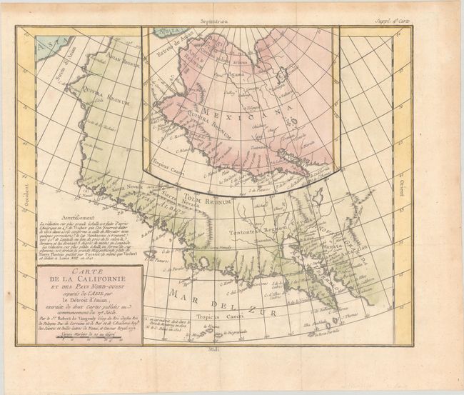
"Carte de la Californie et des Pays Nord-Ouest Separes de l'Asie par le Detroit d'Anian, Extraite de Deux Cartes Publiees au Commencement du 17e Siecle", Robert de Vaugondy, Didier
Subject: Western North America
Period: 1772 (dated)
Publication: Diderot's Encyclopedie (Supplement)
Color: Hand Color
Size:
14.3 x 11.5 inches
36.3 x 29.2 cm
Download High Resolution Image
(or just click on image to launch the Zoom viewer)
(or just click on image to launch the Zoom viewer)
The Encyclopedie was published under the direction of Diderot from 1751 onward with thousands of articles written by the most prominent philosophers and scientists of the time. These great minds collaborated in the goal of assembling and disseminating the fruits of accumulated knowledge and learning. This massive reference work for the arts and sciences, served to propagate Enlightened ideas. Read a full description of this work and Diderot at Wikipedia.com.
This handsome sheet has two contrasting historical maps, one inset into the other. The inset map is based on a world map by Plancius issued in 1641, while the larger map is based on Visscher's map of 1612. Other than a recognizable Baja California, the maps depict a distorted Pacific coastline and are filled with the cartographic myths of the 17th century. The northwest coast bulges too far to the west. Both maps feature the seven cities of Cevola gathered around a spurious lake in the American Southwest.
See also lot 784 for Carl Wheat's Mapping the Transmississippi West that describes this map.
References: Pedley #473; Wagner (NW) #632; Wheat (TMW) #159.
Condition: A
Issued folding, now flat, on a sheet with a bunch of grapes watermark. There is a hint of offsetting and light toning confined to the far blank margins.
Estimate: $140 - $170
Current High Bid:
$0
Reserve: Reserve Not Met
Next Bid: $70
Bid Increments
$50 - $99$5
$100 - $249$10
$250 - $499$25
$500 - $999$50
Terms & Conditions