Current Auction
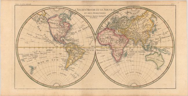
"L'Ancien Monde et le Nouveau en Deux Hemispheres", Bonne, Rigobert
Subject: World
Period: 1780 (circa)
Publication: Atlas de Toutes les Parties Connues du Globe Terrestre
Color: Hand Color
Size:
16.3 x 8.5 inches
41.4 x 21.6 cm
Download High Resolution Image
(or just click on image to launch the Zoom viewer)
(or just click on image to launch the Zoom viewer)
Attractive double hemisphere world map. In North America, the United States is named and confined along the eastern seaboard. The entire western region is blank with the only place names being Santa Fe and Cape Mendocino. There is a large group of islands in the North Pacific including Alaschka in the vicinity of Alaska. Tasmania is attached to Australia, and both islands of New Zealand are depicted.
References:
Condition: B+
A crisp impression, issued folding on a sturdy sheet with light toning and soiling in the top margin.
Estimate: $140 - $170
Current High Bid:
$0
Reserve: Reserve Not Met
Next Bid: $70
Bid Increments
$50 - $99$5
$100 - $249$10
$250 - $499$25
$500 - $999$50
Terms & Conditions