Current Auction
Scarce German Map Illustrating the French & Indian War
"Theatrum Belli in America Septentrionali II. Foiliis Comprehensum...", Rhode, Johann Cristoph
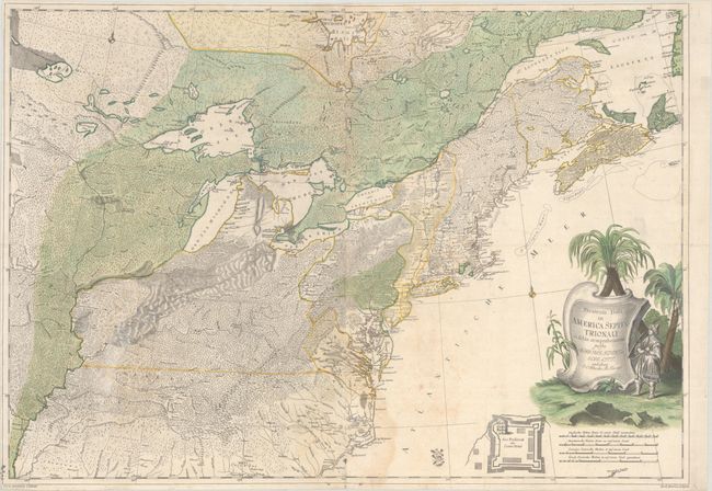
Subject: Colonial Northeastern United States & Canada
Period: 1755 (circa)
Publication:
Color: Hand Color
Size:
31.5 x 22 inches
80 x 55.9 cm
Download High Resolution Image
(or just click on image to launch the Zoom viewer)
(or just click on image to launch the Zoom viewer)
This scarce, separately issued German map (with Latin title) illustrates French and British possessions at the start of the French & Indian War. It is notable for being one of the most accurate maps of the region not published by one of the two warring nations. As such, it is uniquely positioned to present a neutral assessment of boundaries and claims in the eastern United States and Canada. While the map borrows from John Mitchell's epic map, Rhode incorporates additional cartographic sources, including Joshua Fry and Peter Jefferson in the mid-Atlantic and Jean Baptiste Bourguignon d'Anville for the northern portions and the Great Lakes. The map presents English possessions hugging the Atlantic seaboard from Nova Scotia down to the Outer Banks with some early place names including Henricopolis, Dalesgift, and Beverley in Virginia. French possessions are depicted west of the Illinois River and north of the Great Lakes, with the large trans-Appalachia region under dispute. Unlike the Mitchell map that focused primarily on settlements and wagon roads, this map puts an emphasis on the interior wilderness, with an unusual and visually appealing mixture of forests, swamps, savannahs, and mountains. Like Mitchell's map, however, it does locate a fictitious mountain range running down the middle of Michigan and several spurious islands in Lake Superior. The map is decorated by a title cartouche featuring palm trees and a native warrior (in Asian dress). This is the second state of the map, with an inset of Crown Point at bottom.
References: Kershaw #365; McCorkle #755.34; Sellers & Van Ee #59.
Condition: B
Issued folding on watermarked paper with some light foxing and dampstaining. There is a printer's crease to the right of the upper vertical fold and another crease at lower left. Trimmed close to the border at left and top.
Estimate: $8,000 - $9,500
Current High Bid:
$0
Reserve: Reserve Not Met
Next Bid: $4,000
Bid Increments
$2,500 - $4,999$250
$5,000 - $9,999$500
$10,000 - $24,999$1,000
$25,000 - $49,999$2,500
Terms & Conditions