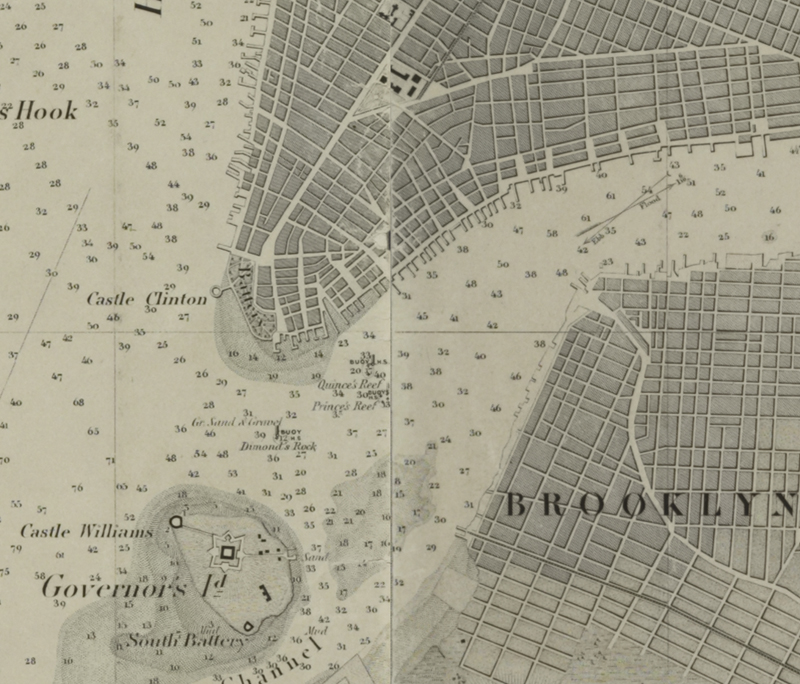
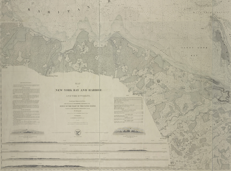
A close-up of New York Bay from Hassler’s mammoth six-sheet map, his crowning achievement. (Image courtesy of the New York Public Library)
Establishing the U.S. Coast Survey: Ferdinand R. Hassler & Alexander D. Bache
by Jon Dotson
Throughout the colonial period and especially following the American Revolution, there was a strong need for accurate charts of the Atlantic coast. Following the Treaty of Paris in 1783, the United States’ coastline stretched from Maine to Georgia, amounting to about 1,500 miles of direct coastline and more than 25,000 miles when considering all of the sounds, bays, rivers, offshore islands, and numerous other coastal features. Navigating through these complexities was certainly no easy task and numerous ships were lost in these waters. At the time, Britain was the leading publisher of charts of the American coastline, including those of J. F. W. Des Barres, a military engineer and surveyor with the British Royal American Regiment.
Following the French & Indian War, Des Barres surveyed the coastlines of Nova Scotia, Newfoundland, and the Gulf of St. Lawrence. Upon his return to London in 1774, the Royal Navy assigned him the task of producing an atlas of new, accurate sea charts of Britain’s empire in North America. In addition to his charts of the Canadian waters, he compiled the manuscripts of British cartographers in the American Colonies, Jamaica and Cuba and published one of the most important sea atlases of the era, The Atlantic Neptune, between 1777 and 1781. It contained the first systematic survey of the east coast of North America, consisting of four volumes and over 250 charts and views. While the Des Barres charts of the New England region, with their rocky (mostly unchanging) coasts, were relatively accurate, this was not the case further south. Rear Admiral Charles Henry Davis (1807-77) explained that due to the sandy shifting bottoms found in the Mid-Atlantic and Southern U.S., the Des Barres charts “have been rendered worse than useless” and that these defects were magnified “by the rapid and extensive changes in the direction, means, and wants of navigation caused by the growth of the country” (Davis, p. 3). In response, several American publishers began to produce their own works hoping to improve on the British charts, including Matthew Clark (Nantucket & Martha’s Vineyard), Thomas Coles and Jonathan Price (North Carolina), and the Blunt family, whose early works included charts of George’s Bank, Long Island Sound, and the Harbor of New London. The Blunt family also produced sailing directions under the title The American Coast Pilot, first published in 1796. Beginning in 1804, Blunt’s sailing directions were augmented with charts to further aid in navigation.
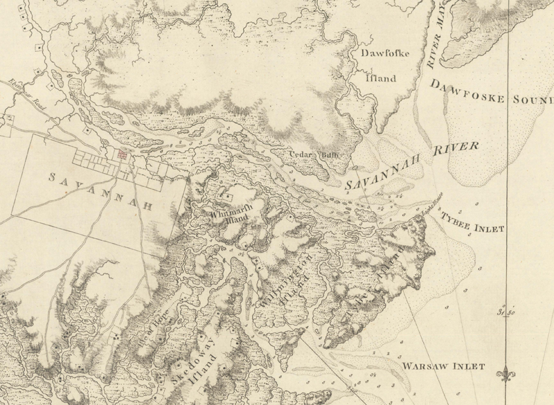
A close-up of Des Barres’ 1780 chart of the Georgia coast and city of Savannah. This was the best contemporary chart of the region. (Image courtesy of Old World Auctions.)
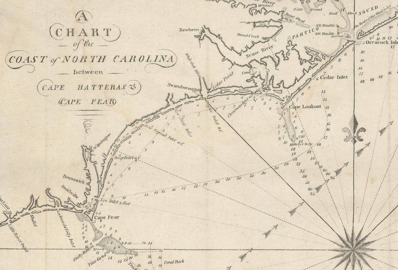
This map was issued in Blunt’s American Coast Pilot for 1809, showing limited detail of the treacherous Outer Banks region. (Image courtesy of Old World Auctions.)
While these early American efforts helped to fill in some coastal cartographic gaps, Congress recognized the need for a more complete solution. Representative Samuel Dana (Connecticut) introduced a resolution on December 15, 1806 to “inquire into the expediency of making provision for a survey of the coasts of the United States, designating the several islands, with the sholas and roads, or places of anchorage, within twenty leagues of any part of the shores of the United States” (p. 6, Forsythe). Dana’s resolution moved through the Committee of Commerce and Manufactures on January 6, 1807, was approved (with a few amendments) by Congress on February 9, 1807, and then signed by President Jefferson the following day, thereby formally establishing the “Survey of the Coast.”
In order to determine the scientific approach to this massive project, Jefferson enlisted Secretary of Treasury Albert Galatin and close adviser Robert Patterson to establish a plan and recommend a candidate to lead the work. Galatin and Patterson received applications from a number of prominent figures in the scientific community, including Isaac Briggs, Andrew Ellicott, John Garnett, Bishop James Madison, and Ferdinand Hassler, a Swiss-born surveyor who had recently emigrated to the United States. Patterson was particularly impressed by Hassler, who had extensive training and technical work experience in Europe using the latest surveying methods. He recommended that Hassler lead the Survey and noted to Jefferson that “he would willingly engage in an exploring expedition, such as those you have already set on foot” (Cajori, p. 119). Jefferson appointed Hassler shortly thereafter.
Coast Survey Under Ferdinand Rudolph Hassler (The Perfectionist)
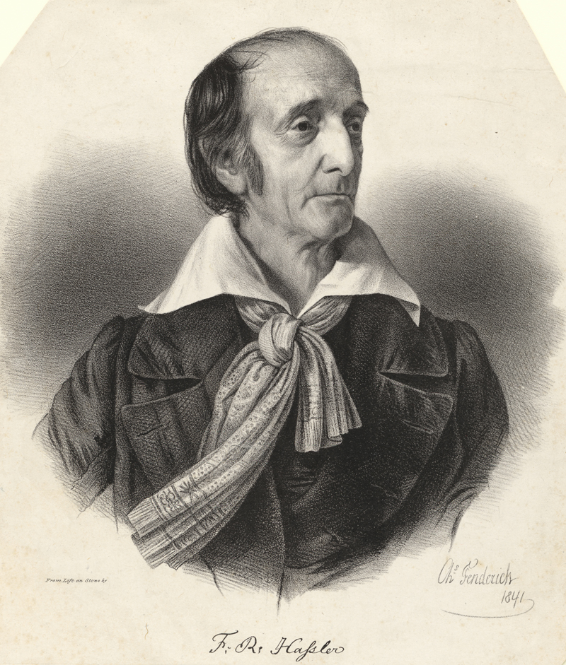
1841 Portrait of Hassler, age of 72 (Image courtesy of the National Portrait Gallery)
Hassler’s vision for charting the American coastline was based upon precise triangulation, utilizing a “lattice-work of large triangles with sides of about 30 miles along the entire coastline. Inside these large triangles would be smaller triangles (about ten miles along each side) to provide a framework for locating any feature within the large triangles” (Hackler, p. 86). The key to these triangles was a very precisely-measured base line (one side of the triangle) from which the other two sides were derived. Despite a strong approach, little in the way of work happened after Hassler was hired by Jefferson. The War of 1812 and funding issues kept Hassler on the sidelines until 1816. When he did get to work, progress was slow. A satisfactory base line was eventually located along a 6-mile stretch of Fire Island (just off of Long Island), and “prominent hills from Connecticut to New Jersey were tied into the triangulation network and base line. At each of these observation points, Hassler developed truncated cones of polished sheet metal which, in direct sunlight, could be seen by the theodolite operator over distances nearing 40 miles” (Hackler, p. 86). Hassler’s methods and superior European equipment (which he had purchased in England during the War of 1812) provided remarkable accuracy not previously seen. By 1817, he had completed a series of triangles linking parts of Connecticut, New York and New Jersey.
In 1818, Hassler’s activities came to an immediate halt due to the passage of a bill which limited employment only to those in the military. This undebated bill appeared to be politically motivated and “Hassler considered Navy Chaplain Chever Felch as the active agent in Congress during 1817 and 1818 in procuring passage of the Act, and in attempts to establish a Navy hydrographic corps” (Guthorn, p. 18). While the Navy subsequently did produce a few local charts for various reasons, the Coast Survey was effectively put on hold until 1832 when the 1807 law was reenacted and amended to allow private citizens to work for the Survey. With funding secured, 62-year-old Hassler continued the work he started decades prior. Since 15 years had passed and both methods and instruments had improved, Hassler determined that a new, longer base line needed to be established and used carefully calibrated metal rods (as opposed to a surveyor’s chain for the 1816 line) to measure a 46,500-foot base line again at Fire Island Beach. Like his earlier efforts, triangles were established and radiated out from Long Island with precision triangles north to Rhode Island (1833) and south to Chesapeake Bay (1841). While these triangulations were important foundations for future charting, “the absence of usable harbor or coast charts was remarked by critics. Hassler, concerned with the precision of his geodetic triangulation, seemed oblivious to the needs of shipmasters; and the government seemed to assume that speedy production of usable charts was implicit in Hassler’s plan” (Guthorn, p. 18).
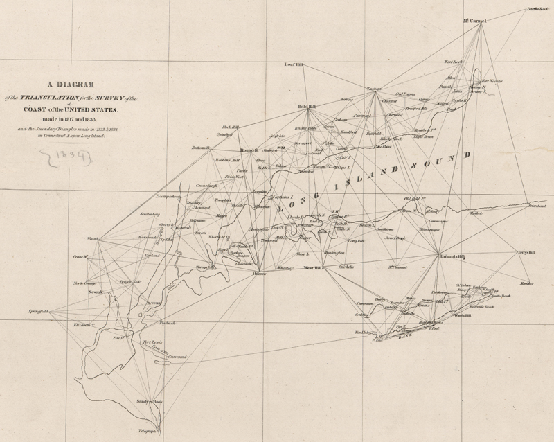
This diagram shows the progress of Hassler’s triangulations through 1834, extending from Sandy Hook, NJ to Mt. Carmel, CT. (Image courtesy of the Library of Congress)
Hassler was so focused on the science and execution of his plan that he failed to recognize the political environment. He was also reluctant to publish work that was not complete. He worried that working charts would be turned “into profit for the private pockets of single individuals, having no exclusive claims to its benefit; and the public would be deluded by being presented with results falsely set up as authentic” (Forsythe, p. 10). While Hassler did manage to produce three charts in 1839 to calm the critics (Bridgeport, New Haven and Newark), a frustrated Congress opened an investigation into its operation in 1841, which resulted in a reorganization of the Survey and the establishment of a board to provide scientific oversight. Finally, having acquired a copperplate printing press in 1842 and hiring a staff of skilled engravers and printers, Hassler was ready to begin sharing the fruits of his labors in the way that he envisioned. In 1843, engraving began on Hassler’s six-sheet chart of New York Harbor – his crowning achievement. This chart was particularly noteworthy for revealing a new and important deep-water channel into the harbor of both commercial and military benefit named Gedney’s Channel (named after its surveyor Lt. Thomas Gedney). Unfortunately, Hassler died before the map would be published to much fanfare in 1844.
This image shows just a portion of Hassler's mammoth chart of New York Harbor. It features incredible detail of both hydrology and topography. (Image courtesy of the New York Public Library)
Coast Survey Under Alexander Dallas Bache (The Maximizer)
Following Hassler as the second Superintendent of the Coast Survey was Alexander Dallas Bache. Bache was the great-grandson of Benjamin Franklin, and was an accomplished scientist and surveyor. Among his scientific accomplishments was the founding of a magnetic observatory and serving as the first president of the National Academy of Sciences. Unlike Hassler, however, Bache was very aware of the political landscape and implemented immediate changes to how the Survey operated. “Bache grasped that the Survey work was of little use unless it became visible and useful to mariners. As soon as he took command, the copper plates that had been under way for years were finished, and a series of magnificent charts appeared, the finest cartography yet produced in the New World” (Cloud 2007). Bache reworked the requirements for triangulation, hydrology, and topography and brought in two highly-trained German scientists: Julius Hilgard (who would later become Superintendent) and Charles Anthony Schott. Of particular importance, he divided the survey work into geographic sections along the Atlantic (and later Gulf of Mexico and Pacific Ocean), and required that survey work be completed in each section every year. In order to effectively share this “work in progress” with Congress and the public, Bache adopted new nomenclature to indicate progress including “sketch” maps and “preliminary” charts. Sketches dealt with small geographic areas using primarily reconnaissance, but were not audited. Preliminary charts were more detailed and “were drawn and engraved as each season’s work was drawing to a close. They served the immediate needs for navigation, as information for private chart publishers, the needs of other interested persons, and as a measure of the overall work of the Survey” (Guthorn, p. 19). Bache’s approach was well received by Congress and he was able to quadruple the Survey’s budget after his first year of operation.
These two charts of Galveston Bay show a preliminary “sketch” (top) and a final chart (bottom). While soundings are identical, the latter chart notes new buoys, beacons, and notations not found on the sketch. (Images courtesy of Old World Auctions.)
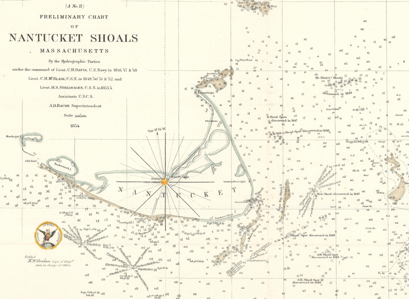
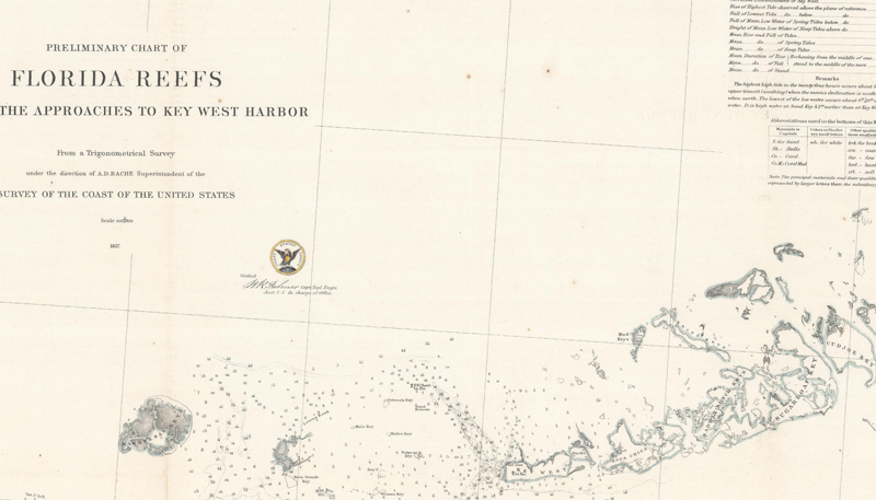
Outside of a few early reports, Bache disseminated Coast Survey data through annual reports beginning in 1846 and entitled “Report of the Superintendent of the United States Coast Survey Showing the Progress of the Work.” The Coast Survey grew significantly under Bache’s direction, in part because of the quality of the work being done but also due to the country’s growing footprint. The additions of Texas and the Southwest to the U.S. brought huge new stretches of coast to chart. In 1851, Bache established functional divisions to handle all this new work including computing, drawing, engraving, printing, publishing, distribution, archives and more. For that year, the Survey produced over 26,000 sheets of information – a stark contrast to the years under Hassler. The annual reports continued to cover the team’s geographic sections in fine detail, with the 1856 report addressing the inconsistent use of scale and establishing three standard classes of charts going forward. Work along the Pacific Coast was included in the 1859 report. In the 1860 report, issued just before the Civil War began, Bache noted the Survey’s accomplishments to date: “The number of geographical determinations published by the Coast Survey, exclusive of those made within the past year, is seven thousand one hundred and seventy-eight; the magnetic variations given are upwards of two hundred; the tidal constants for harbors and coasts, one hundred and ten; and the maps and charts of harbors, bays, inlets, sounds, shoals, &c., drawn, engraved, and published, three hundred, exclusive of progress sketches and diagrams.” Some of the more celebrated works completed under Bache include surveying Nantucket Shoals, Florida Keys, and Buttermilk Channel in the New York Bay. Bache guided the Coast Survey through the Civil War, shifting both priorities and resources toward the Union war effort (while losing some officers to the Confederacy). Bache also oversaw the establishment of a lithography department, which enabled the Coast Survey to rapidly produce charts as needed for the front lines. Though his personnel looked very different following the War, Bache was able resume the Survey’s normal activities once peace was established. After Bache passed away in 1867, he was succeeded by Benjamin Peirce, who carried on the Coast Survey’s activities as Superintendent.
The treacherous Nantucket Shoals was one of the most difficult areas to survey, with water levels as shallow as 3 feet. (Image courtesy of Old World Auctions.)
As the population headed west, more ships (and economic value) headed through the Strait of Florida, necessitating a thorough understanding of these waters to avoid commercial losses. (Image courtesy of Old World Auctions.)
Both Ferdinand Hassler and Alexander Bache made significant contributions to the establishment of a government-sponsored American charting capability. Hassler laid the initial scientific framework and Bache made the Survey’s progress more dynamic and visible to the public. While the organization’s name changed over the years (“Survey of the Coast” in 1807, “Coast Survey” in 1836, and “Coast & Geodetic Survey” in 1878), the unwavering dedication of its early leadership provided a wide range of reports, observations, and charts which facilitated the country’s economic trade, enhanced national defense, and supplied commercial map publishers with up-to-date information.
REFERENCES
Cajori, Florian. “Swiss Geodesy and the United States Coast Survey.” The Scientific Monthly, Vol. 13, No. 2 (Aug. 1921).
Cloud, John. “The 200th Anniversary of the Survey of the Coast.” Prologue Magazine, Vol. 39, No. 1 (Spring 2007). https://www.archives.gov/publications/prologue/2007/spring/coast-survey.html
Davis, Charles Henry. The Coast Survey of the United States. Washington: Gideon & Co. Printers, 1851.
Forsythe, Dawn. “Nautical Charts Contribute to Economic Growth and National Defense, 1807-1975.” Published April 2017. https://nauticalcharts.noaa.gov/about/docs/history-of-coast-survey/nautical-charts-contribute-to-economic-development-and-national-defense.pdf
Guthorn, Peter J. United States Coastal Charts 1783-1861. Exton: Schiffer Publishing Limited, 1984.
Hackler, David L. “The Brilliant, Irascible Ferdinand Rudolph Hassler.” Mercator’s World, Vol. 1, No. 1 (1996), pp. 84-88.