Showing Featured Lots(remove filter)
Filtered by Category:Europe & Mediterranean(Show All Categories)
Showing results for:Auction 199
Catalog Archive
8 lots
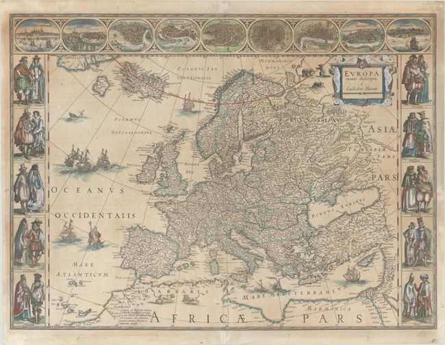
Auction 199, Lot 363
Subject: Europe
Blaeu, Willem
Europa Recens Descripta, 1635
Size: 21.9 x 16.1 inches (55.6 x 40.9 cm)
Estimate: $2,750 - $3,500
Blaeu's Carte-a-Figures Map of Europe
Sold for: $1,500
Closed on 9/11/2024
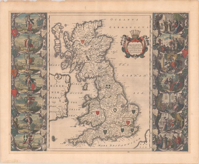
Auction 199, Lot 375
Subject: Britain
Blaeu, Johannes
Britannia Prout Divisa Suit Temporibus Anglo-Saxonum, Praesertim Durante Illorum Heptarchia, 1646
Size: 20.8 x 16.3 inches (52.8 x 41.4 cm)
Estimate: $1,600 - $1,900
Blaeu's Decorative Map of Britain with Vignettes of Saxon History
Sold for: $850
Closed on 9/11/2024
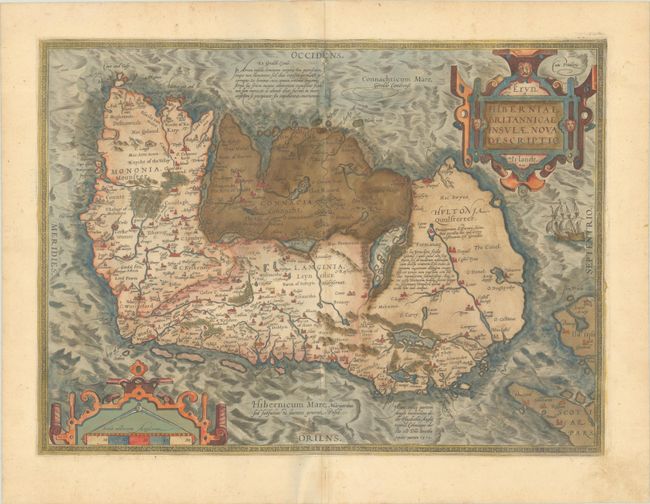
Auction 199, Lot 398
Subject: Ireland
Ortelius, Abraham
Eryn. Hiberniae, Britannicae Insulae, Nova Descriptio. Irlandt, 1579
Size: 19 x 13.9 inches (48.3 x 35.3 cm)
Estimate: $1,100 - $1,400
Ortelius' First Map of Ireland in Full Contemporary Color
Sold for: $800
Closed on 9/11/2024
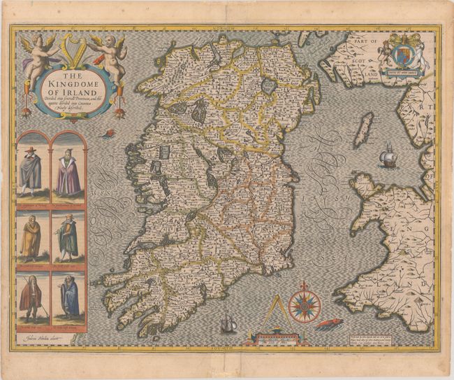
Auction 199, Lot 399
Subject: Ireland
Speed, John
The Kingdome of Irland Devided into Severall Provinces, and the Againe Devided into Counties. Newly Described, 1610
Size: 20 x 15.3 inches (50.8 x 38.9 cm)
Estimate: $2,750 - $3,500
One of the Most Desired Maps of Ireland
Sold for: $2,000
Closed on 9/11/2024
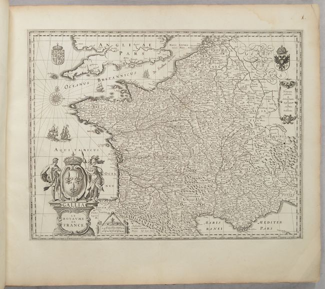
Auction 199, Lot 436
Subject: France, Atlases
Blaeu, (Family)
[Volume 2, Part 1] Novus Atlas, das ist Welt-beschreibung mit Schoenen Newen Ausfuehrlichen Land-Taffeln..., 1647
Size: 24 x 20 inches (61 x 50.8 cm)
Estimate: $4,500 - $5,500
Price Reduced by $300! Superb Atlas of France with 48 Maps
Unsold
Closed on 9/11/2024
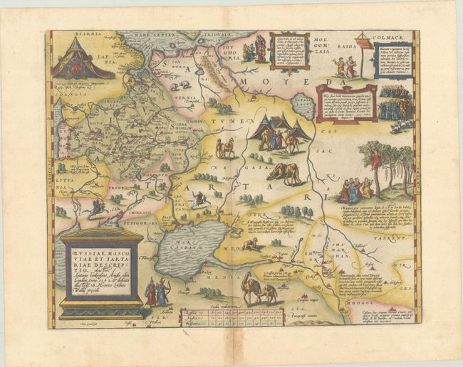
Auction 199, Lot 507
Subject: Russia, Eastern Europe & Central Asia
Ortelius, Abraham
Russiae, Moscoviae et Tartariae Descriptio. Auctore Antonio Ienkensono Anglo..., 1575
Size: 17.4 x 13.8 inches (44.2 x 35.1 cm)
Estimate: $1,600 - $1,900
Ortelius' Map of Russia with a Vignette of Ivan the Terrible
Sold for: $1,200
Closed on 9/11/2024
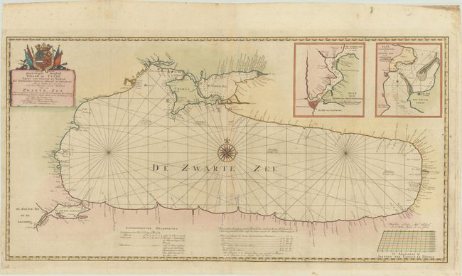
Auction 199, Lot 518
Subject: Black Sea
van Keulen en Zoonen, Johannes
Aan Zyne Doorluchtigste Hoogheid Willem de Vyfde ... Wassende Graade Paskaart van de Zwarte Zee..., 1775
Size: 38 x 19.4 inches (96.5 x 49.3 cm)
Estimate: $1,100 - $1,400
Rare Two-Sheet Map of Black Sea Based on Work by Captain Van Kinsbergen
Sold for: $3,250
Closed on 9/11/2024
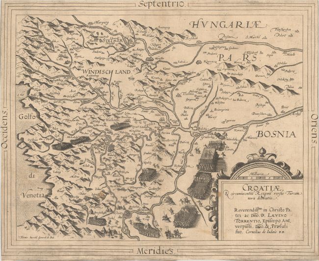
Auction 199, Lot 528
Subject: Croatia
Jode, Cornelis de
Croatiae, & Circumiacentiu Regionu Versus Turcam Nova Delineatio, 1593
Size: 15.6 x 12.9 inches (39.6 x 32.8 cm)
Estimate: $950 - $1,100
Rare Map of Croatia During Long Turkish War
Unsold
Closed on 9/11/2024
8 lots