Showing Featured Lots(remove filter)
Filtered by Category:United States(Show All Categories)
Showing results for:Auction 202
Catalog Archive
19 lots
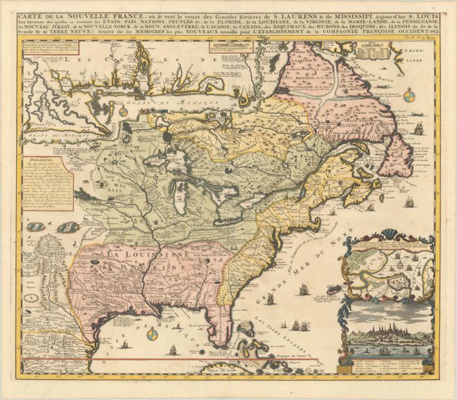
Auction 202, Lot 102
Subject: Colonial Eastern United States & Canada
Chatelain, Henry Abraham
Carte de la Nouvelle France, ou se voit les Cours des Grandes Rivieres de S. Laurens & de Mississipi Aujour d'hui S. Louis, aux Environs des quelles se Trouvent les Etats, Pais, Nations, Peuples &c. de la Floride, de la Louisiane, de la Virginie..., 1719
Size: 19 x 16.5 inches (48.3 x 41.9 cm)
Estimate: $3,000 - $3,750
One of the Most Informative 18th Century Maps of the French Possessions in North America
Sold for: $2,000
Closed on 2/12/2025
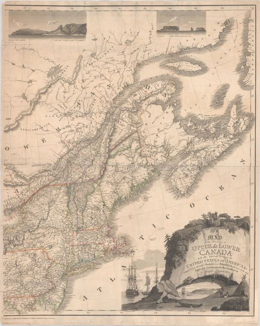
Auction 202, Lot 106
Subject: Northeastern United States & Canada
Bouchette, Joseph
[Eastern Sheet] Map of the Provinces of Upper & Lower Canada with the Adjacent Parts of the United States of America &c. Compiled from the Latest Surveys and Adjusted from the Most Recent and Approved Astronomical Observations, 1815
Size: 24.3 x 30 inches (61.7 x 76.2 cm)
Estimate: $2,750 - $3,500
Eastern Sheet of Bouchette's Rare Map Presenting Lower Canada and New England
Unsold
Closed on 2/12/2025
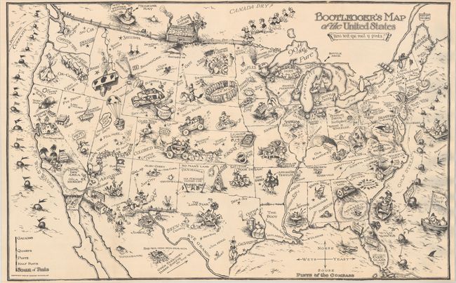
Auction 202, Lot 118
Subject: United States
Bootlegger's Map of the United States, 1926
Size: 33.9 x 21.3 inches (86.1 x 54.1 cm)
Estimate: $1,100 - $1,400
McCandlish's Humorous Prohibition Map
Sold for: $900
Closed on 2/12/2025
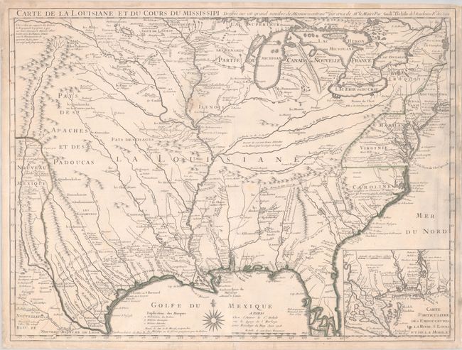
Auction 202, Lot 122
Subject: Colonial Eastern United States
Delisle, Guillaume
Carte de la Louisiane et du Cours du Mississipi Dressee sur un Grand Nombre de Memoires Entrau'tres sur ceux de Mr. le Maire, 1718
Size: 25.7 x 19.3 inches (65.3 x 49 cm)
Estimate: $4,750 - $6,000
A Foundation Map for the Mississippi Valley and the First Appearance of Texas on a Printed Map - First Issue
Sold for: $2,650
Closed on 2/12/2025
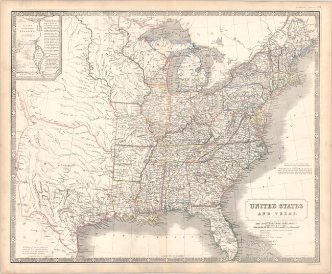
Auction 202, Lot 128
Subject: Eastern United States, Texas
Johnston, Alexander K.
United States and Texas, 1842
Size: 24.3 x 19.8 inches (61.7 x 50.3 cm)
Estimate: $1,200 - $1,500
Scottish Atlas Map Featuring the Independent Republic of Texas
Sold for: $900
Closed on 2/12/2025
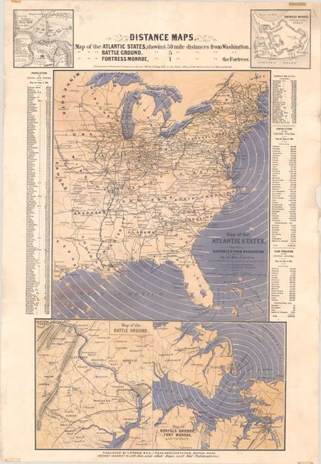
Auction 202, Lot 130
Subject: Eastern United States, Civil War
Prang, Louis
Distance Maps. Map of the Atlantic States Showing 50 Mile Distances from Washington..., 1861
Size: 15 x 22.1 inches (38.1 x 56.1 cm)
Estimate: $1,100 - $1,400
Rare Civil War Distance Map
Sold for: $650
Closed on 2/12/2025
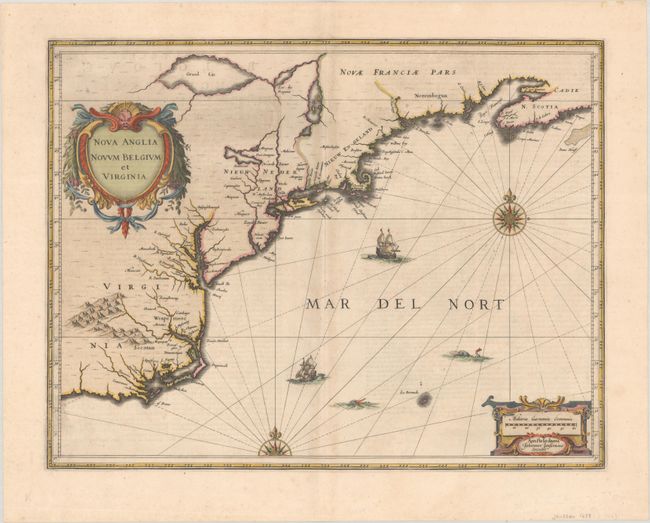
Auction 202, Lot 134
Subject: Colonial New England & Mid-Atlantic United States
Jansson, Jan
Nova Anglia Novum Belgium et Virginia, 1639
Size: 19.8 x 15.3 inches (50.3 x 38.9 cm)
Estimate: $1,200 - $1,500
First State of Jansson's Influential Map of the East Coast
Sold for: $700
Closed on 2/12/2025
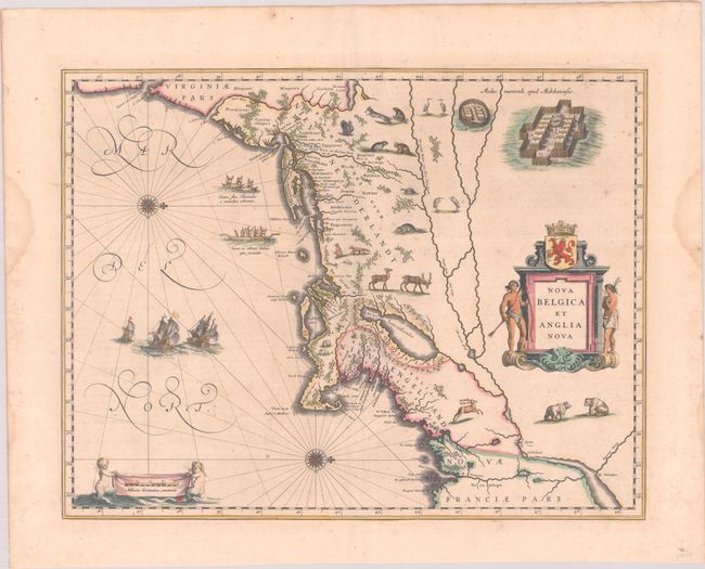
Auction 202, Lot 135
Subject: Colonial New England & Mid-Atlantic United States
Blaeu, Willem
Nova Belgica et Anglia Nova, 1640
Size: 19.8 x 15.3 inches (50.3 x 38.9 cm)
Estimate: $1,900 - $2,200
Important Map of Colonial New England and the Mid-Atlantic in Full Contemporary Color
Sold for: $1,400
Closed on 2/12/2025
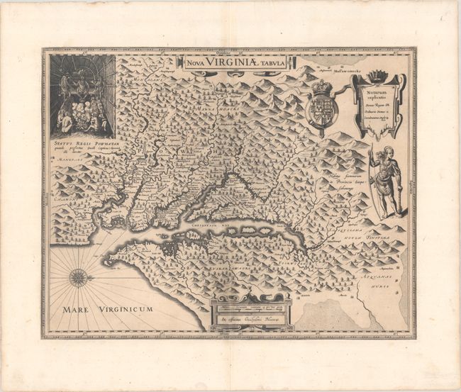
Auction 202, Lot 147
Subject: Colonial Mid-Atlantic United States
Hondius/Blaeu
Nova Virginiae Tabula, 1630
Size: 19.1 x 14.9 inches (48.5 x 37.8 cm)
Estimate: $1,400 - $1,700
One of the Most Important 17th Century Maps of the Chesapeake Bay
Sold for: $1,000
Closed on 2/12/2025
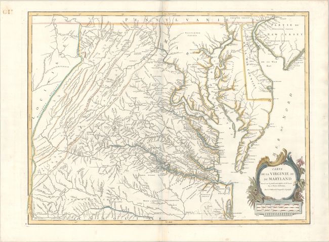
Auction 202, Lot 154
Subject: Mid-Atlantic United States
Robert de Vaugondy, Didier
Carte de la Virginie et du Maryland Dressee sur la Grande Carte Angloise de Mrs. Josue Fry et Pierre Jefferson, 1793
Size: 25.3 x 19 inches (64.3 x 48.3 cm)
Estimate: $1,400 - $1,700
An Essential Map of Virginia and Maryland
Sold for: $1,000
Closed on 2/12/2025

Auction 202, Lot 156
Subject: Mid-Atlantic United States, Civil War
Bachmann, John
Panorama of the Seat of War. Birds Eye View of Virginia, Maryland Delaware and the District of Columbia, 1861
Size: 28.1 x 18.1 inches (71.4 x 46 cm)
Estimate: $1,800 - $2,200
Bachmann's Dramatic View of the Mid-Atlantic Region
Sold for: $1,700
Closed on 2/12/2025
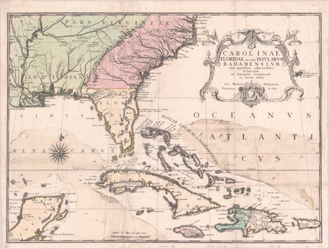
Auction 202, Lot 158
Subject: Colonial Southeastern United States, Bahamas & Greater Antilles
Seligmann, Johann Michael
Carolinae Floridae nec non Insularum Bahamensium cum Partibus Adjacendibus Delineatio ad Exemplar Londinense in Lucem Edita, 1755
Size: 23 x 17 inches (58.4 x 43.2 cm)
Estimate: $3,250 - $4,000
German Edition of Catesby's Scarce and Important Map of the Southeastern United States
Sold for: $2,400
Closed on 2/12/2025
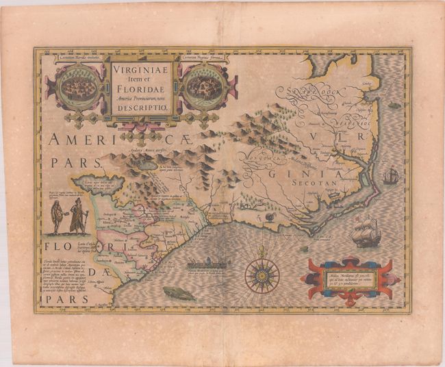
Auction 202, Lot 159
Subject: Colonial Southeastern United States
Hondius, Jodocus
Virginiae Item et Floridae Americae Provinciarum, Nova Descriptio, 1619
Size: 19.1 x 13.5 inches (48.5 x 34.3 cm)
Estimate: $1,400 - $1,700
A Seminal Map of the Southeast and Early American Cartography in Full Contemporary Color
Unsold
Closed on 2/12/2025
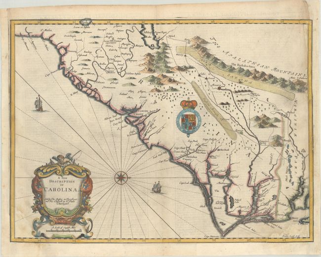
Auction 202, Lot 161
Subject: Colonial Southeastern United States
Speed/Lamb
A New Description of Carolina, 1676
Size: 20 x 14.9 inches (50.8 x 37.8 cm)
Estimate: $2,200 - $2,500
Speed's Map of the Carolinas Based Upon the Lords Proprietor's Map
Unsold
Closed on 2/12/2025
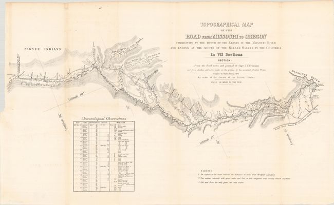
Auction 202, Lot 179
Subject: Western United States
Fremont/Preuss
[Lot of 7] Topographical Map of the Road from Missouri to Oregon Commencing at the Mouth of the Kansas in the Missouri River...In VII Sections... [with] Report No. 145...Canal or Railroad Between the Atlantic and Pacific Oceans, 1849
Size: 24.5 x 12.8 inches (62.2 x 32.5 cm)
Estimate: $3,000 - $3,750
Scarce Seven-Part Oregon Trail Map
Sold for: $3,000
Closed on 2/12/2025
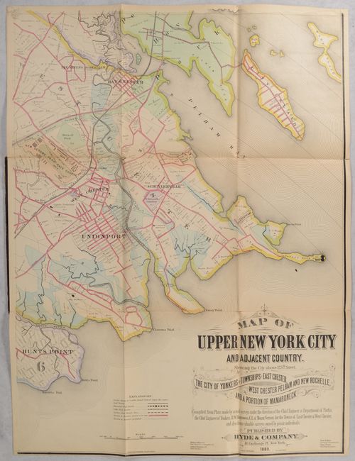
Auction 202, Lot 240
Subject: New York City, New York
[On 4 Sheets] Map of Upper New York City and Adjacent Country. Showing the City Above 125th Street. The City of Yonkers and Townships of East Chester..., 1889
Size: 23.3 x 31 inches (59.2 x 78.7 cm)
Estimate: $900 - $1,100
Elaborate 4-Sheet Map of Upper New York City and Westchester County
Sold for: $650
Closed on 2/12/2025

Auction 202, Lot 261
Subject: Documents - Texas Independence
[Texas Independence] Niles' Weekly Register ... from March, 1836, to September, 1836..., 1836
Size: 6.4 x 9.8 inches (16.3 x 24.9 cm)
Estimate: $750 - $900
Texas Independence and Much More
Sold for: $550
Closed on 2/12/2025
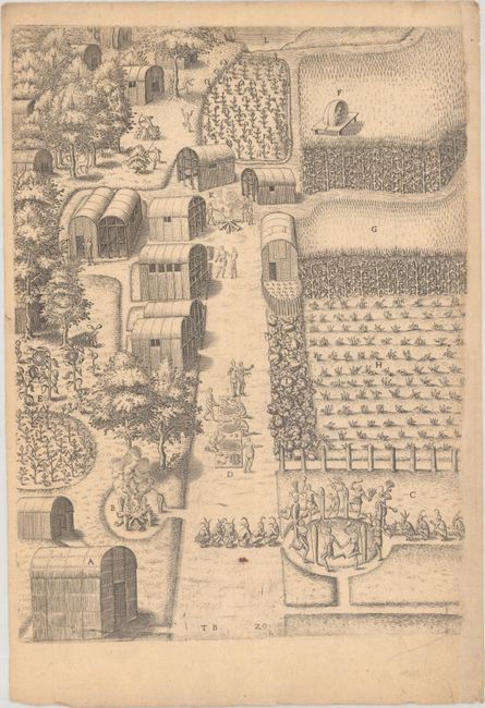
Auction 202, Lot 262
Subject: Virginia, Native Americans
Bry, Theodore de
[Grands Voyages, Part I] Admiranda Narratio Fida Tamen, de Commodis et Incolarum Ritibus Virginiae, Nuper Admodum ab Anglis..., 1608
Size: 9.1 x 13.7 inches (23.1 x 34.8 cm)
Estimate: $2,000 - $2,400
Set of De Bry's Native Virginians & Picts from Part I of Grands Voyages
Sold for: $2,500
Closed on 2/12/2025
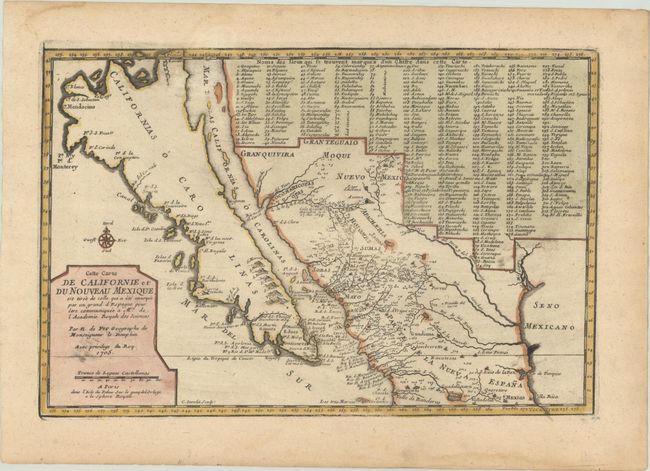
Auction 202, Lot 269
Subject: Southwestern United States & Mexico, California
Fer, Nicolas de
Cette Carte de Californie et du Nouveau Mexique, est Tiree de Celle qui a ete Envoyee par un Grand d'Espagne pour etre Communiquee a Mrs. de l'Academie Royale des Sciences, 1705
Size: 13.3 x 8.8 inches (33.8 x 22.4 cm)
Estimate: $1,000 - $1,300
De Fer's Important Map of the Island of California
Sold for: $750
Closed on 2/12/2025
19 lots