Filtered by Category:Pacific Ocean, New Zealand, Australia(Show All Categories)
Showing results for:Auction 202
Catalog Archive
14 lots
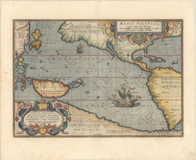
Auction 202, Lot 695
Subject: Pacific Ocean, Western Hemisphere
Ortelius, Abraham
Maris Pacifici, (quod Vulgo Mar del Zur) cum Regionibus Circumiacentibus, Insulisque in Eodem Passim Sparsis, Novissima Descriptio, 1589
Size: 19.7 x 13.6 inches (50 x 34.5 cm)
Estimate: $8,000 - $9,500
The First Printed Map Devoted to the Pacific
Sold for: $6,000
Closed on 2/12/2025
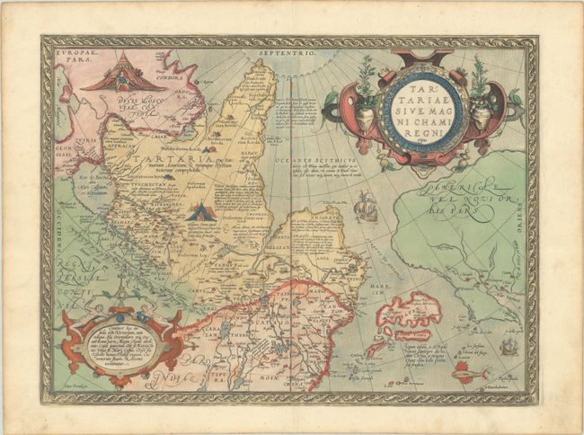
Auction 202, Lot 696
Subject: North Pacific, Northern Asia & Northwestern North America
Ortelius, Abraham
Tartariae sive Magni Chami Regni Typus, 1573
Size: 18.6 x 13.9 inches (47.2 x 35.3 cm)
Estimate: $1,100 - $1,400
Sold for: $800
Closed on 2/12/2025
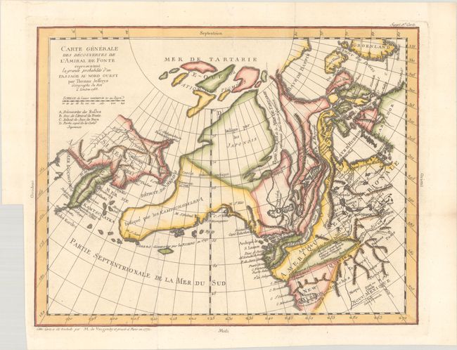
Auction 202, Lot 697
Subject: North Pacific Ocean
Robert de Vaugondy, Didier
Carte Generale des Decouvertes de l'Amiral de Fonte representant la grande probabilite d'un Passage au Nord Ouest, 1772
Size: 14.6 x 11.3 inches (37.1 x 28.7 cm)
Estimate: $140 - $170
Sold for: $100
Closed on 2/12/2025
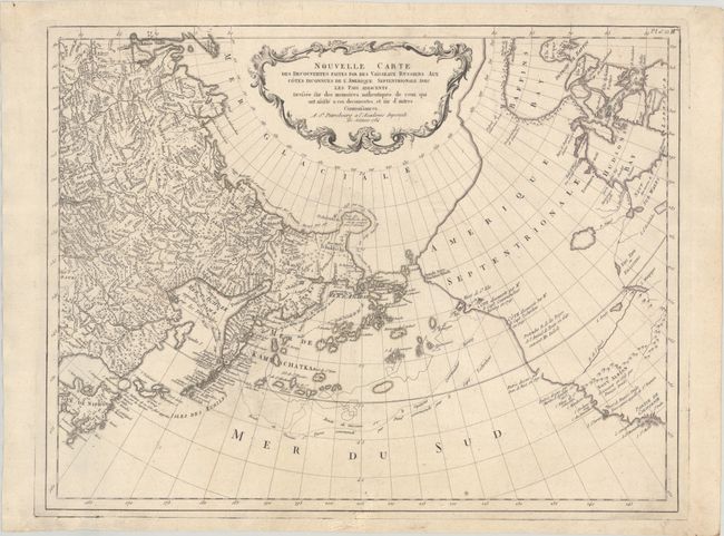
Auction 202, Lot 698
Subject: North Pacific Ocean
Santini/Remondini
Nouvelle Carte des Decouvertes Faites par des Vaisseaux Russiens aux Cotes Inconnues de l'Amerique Septentrionale avec les Pais Adiacents..., 1784
Size: 24.9 x 19.3 inches (63.2 x 49 cm)
Estimate: $550 - $700
Unsold
Closed on 2/12/2025

Auction 202, Lot 699
Subject: South Pacific Ocean
Bellin, Jacques Nicolas
Carte Reduite de la Mer du Sud pour Servir a l'Histoire Generale des Voyages, 1753
Size: 14.3 x 8.3 inches (36.3 x 21.1 cm)
Estimate: $240 - $300
Sold for: $120
Closed on 2/12/2025
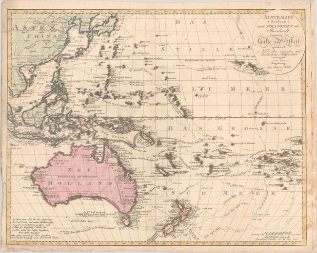
Auction 202, Lot 700
Subject: South Pacific Ocean, Australia
Walch, Johannes
Australien (Sudland) auch Polynesien odern Inselwelt, Insgemein der Funfte Welttheil..., 1802
Size: 23.6 x 18.7 inches (59.9 x 47.5 cm)
Estimate: $550 - $700
Sold for: $400
Closed on 2/12/2025

Auction 202, Lot 701
Subject: Papua New Guinea & Northern Australia
Anon.
A Curious Map of Some Late Discoveries in the Terra Australis Comprehending New Guinea & New Britain, 1763
Size: 7.3 x 4.4 inches (18.5 x 11.2 cm)
Estimate: $190 - $220
Sold for: $180
Closed on 2/12/2025
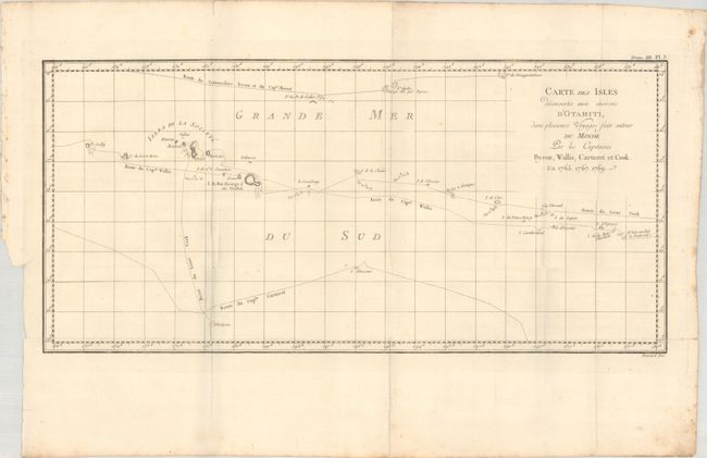
Auction 202, Lot 702
Subject: Society Islands, Tahiti
Benard, Robert
Carte des Isles Decouvertes aux Environs d'Otahiti, dans Plusieurs Voyages Faits Autour du Monde par les Capitaines Byron, Wallis, Carteret et Cook. En 1765. 1767. 1769, 1774
Size: 20.3 x 9.6 inches (51.6 x 24.4 cm)
Estimate: $50 - $70
NO RESERVE
Sold for: $55
Closed on 2/12/2025
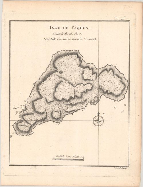
Auction 202, Lot 703
Subject: Easter Island
Cook/Benard
[Lot of 2] Isle de Paques [and] Femme de l'Isle de Paques, 1780
Size: See Description
Estimate: $100 - $130
NO RESERVE
Sold for: $48
Closed on 2/12/2025
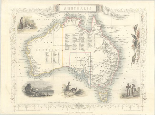
Auction 202, Lot 704
Subject: Australia
Tallis, John
Australia, 1850
Size: 13 x 10 inches (33 x 25.4 cm)
Estimate: $240 - $300
Sold for: $150
Closed on 2/12/2025

Auction 202, Lot 705
Subject: Tasmania
Cook/Hogg
Chart of Van Diemen's Land, 1784
Size: 13.4 x 8.8 inches (34 x 22.4 cm)
Estimate: $100 - $130
Sold for: $75
Closed on 2/12/2025
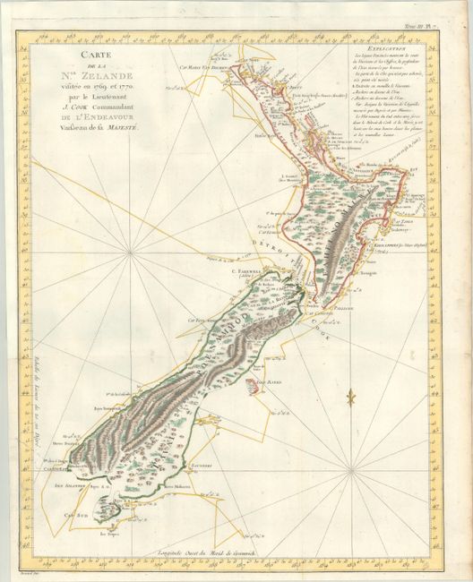
Auction 202, Lot 706
Subject: New Zealand
Cook/Benard
Carte de la Nle. Zelande Visitee en 1769 et 1770. Par le Lieutenant J. Cook Commandant de l'Endeavour Vaisseau de sa Majeste, 1774
Size: 14.8 x 18.8 inches (37.6 x 47.8 cm)
Estimate: $1,500 - $1,800
The First Complete Map of New Zealand
Sold for: $1,300
Closed on 2/12/2025
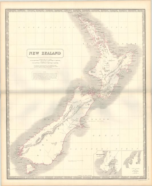
Auction 202, Lot 707
Subject: New Zealand
Black, Adam & Charles
New Zealand, 1843
Size: 10.9 x 15.1 inches (27.7 x 38.4 cm)
Estimate: $110 - $140
NO RESERVE
Sold for: $140
Closed on 2/12/2025
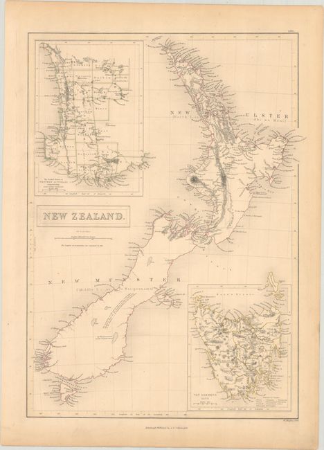
Auction 202, Lot 708
Subject: New Zealand
Johnston, Alexander K.
New Zealand, 1845
Size: 19.8 x 24.1 inches (50.3 x 61.2 cm)
Estimate: $140 - $170
Sold for: $70
Closed on 2/12/2025
14 lots