Showing Featured Lots(remove filter)
Filtered by Category:United States(Show All Categories)
Showing results for:Auction 199
Catalog Archive
18 lots
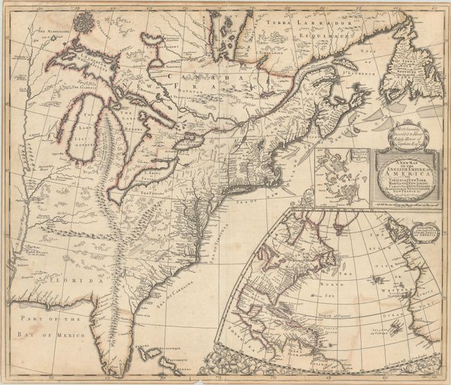
Auction 199, Lot 101
Subject: Colonial Eastern United States & Canada
Senex, John
A New Map of the English Empire in America viz Virginia Maryland Carolina Pennsylvania New York New Iarsey New England Newfoundland New France &c., 1719
Size: 23.3 x 19.8 inches (59.2 x 50.3 cm)
Estimate: $2,400 - $3,000
Senex's Important Map of the American Colonies
Sold for: $1,800
Closed on 9/11/2024
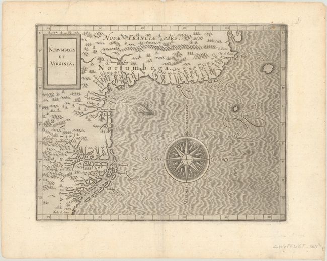
Auction 199, Lot 105
Subject: Colonial Northeastern United States & Canada
Wytfliet, Cornelis
Norumbega et Virginia, 1607
Size: 11.6 x 9.1 inches (29.5 x 23.1 cm)
Estimate: $2,750 - $3,500
Important, Early Map of the East Coast with Mythical City
Sold for: $2,000
Closed on 9/11/2024
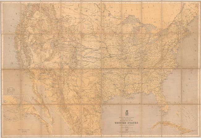
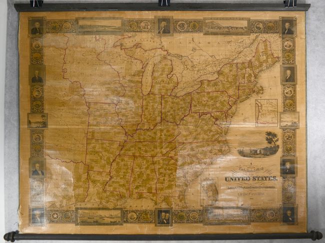
Auction 199, Lot 118
Subject: United States
U.S. War Department
Military Map of the United States, 1869
Size: 41.3 x 28.3 inches (104.9 x 71.9 cm)
Estimate: $2,400 - $3,000
Reduced Version of Freyhold's 1868 Map
Sold for: $1,500
Closed on 9/11/2024
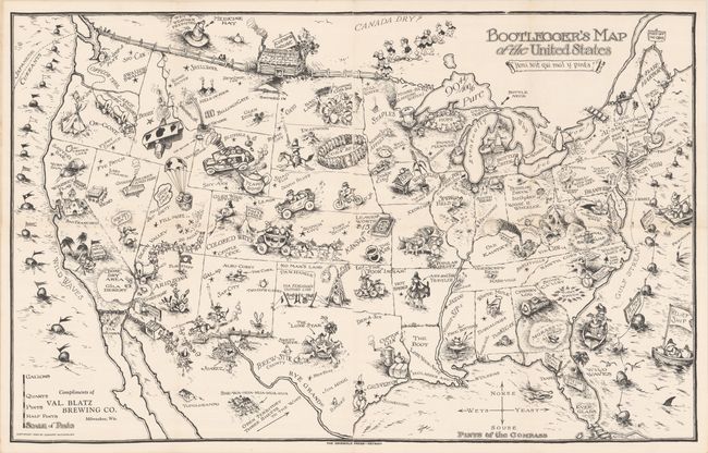
Auction 199, Lot 121
Subject: United States
Bootlegger's Map of the United States, 1926
Size: 34.1 x 21.4 inches (86.6 x 54.4 cm)
Estimate: $1,400 - $1,700
McCandlish's Humorous Prohibition Map
Sold for: $850
Closed on 9/11/2024
Auction 199, Lot 122
Subject: United States, Aviation
Rand McNally & Co.
Illustrated Map of the Route of Transcontinental Air Transport, Inc. , 1929
Size: 30.9 x 14.1 inches (78.5 x 35.8 cm)
Estimate: $1,100 - $1,400
One of the Earliest Commercial Airline Maps
Sold for: $800
Closed on 9/11/2024
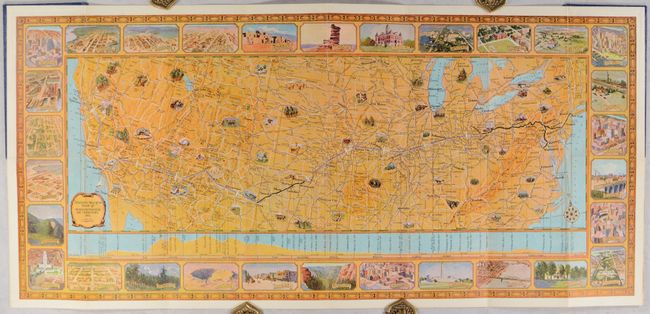
Auction 199, Lot 129
Subject: Eastern United States
A New and Embellished Map of the United States. Compiled from the Latest & Most Authentic Documents, 1845
Size: 47.4 x 36.3 inches (120.4 x 92.2 cm)
Estimate: $2,750 - $3,500
Decorative Wall Map in Contemporary Color
Sold for: $1,800
Closed on 9/11/2024
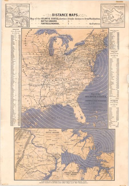
Auction 199, Lot 132
Subject: Eastern United States, Civil War
Prang, Louis
Distance Maps. Map of the Atlantic States Showing 50 Mile Distances from Washington..., 1861
Size: 15 x 22.1 inches (38.1 x 56.1 cm)
Estimate: $1,400 - $1,700
Rare Civil War Distance Map
Unsold
Closed on 9/11/2024
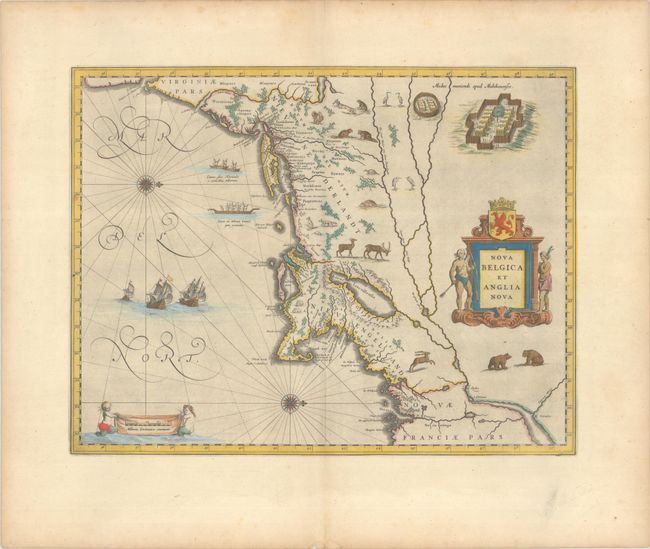
Auction 199, Lot 135
Subject: Colonial New England & Mid-Atlantic United States
Blaeu, (Family)
Nova Belgica et Anglia Nova, 1663
Size: 19.9 x 15.3 inches (50.5 x 38.9 cm)
Estimate: $2,000 - $2,300
Important Map of Colonial New England and the Mid-Atlantic
Sold for: $1,800
Closed on 9/11/2024
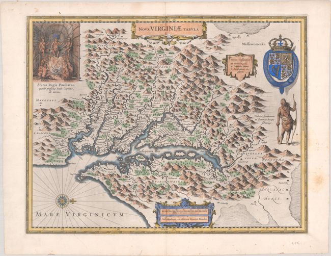
Auction 199, Lot 141
Subject: Colonial Mid-Atlantic United States
Hondius, Henricus
Nova Virginiae Tabula, 1630
Size: 19.4 x 15.1 inches (49.3 x 38.4 cm)
Estimate: $2,000 - $2,300
One of the Most Important 17th Century Maps of the Chesapeake Bay
Sold for: $1,700
Closed on 9/11/2024
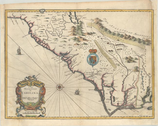
Auction 199, Lot 151
Subject: Colonial Southeastern United States
Speed/Lamb
A New Description of Carolina, 1676
Size: 20 x 14.9 inches (50.8 x 37.8 cm)
Estimate: $2,400 - $3,000
Speed's Map of the Carolinas Based Upon the Lords Proprietor's Map
Unsold
Closed on 9/11/2024
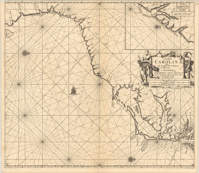
Auction 199, Lot 152
Subject: Colonial Southeastern United States
Keulen, Johannes van
Pas Kaart van de Kust van Carolina Tusschen C de Canaveral en C Henry, 1702
Size: 23 x 20.3 inches (58.4 x 51.6 cm)
Estimate: $2,300 - $2,750
Scarce Dutch Chart of the Carolinas
Unsold
Closed on 9/11/2024
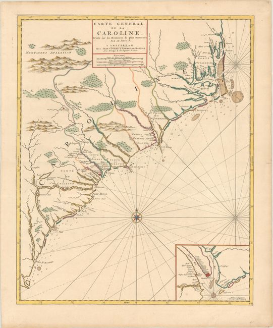
Auction 199, Lot 153
Subject: Colonial Southeastern United States
Covens & Mortier
Carte General de la Caroline. Dresse sur les Memoires le Plus Nouveaux par le Sieua S..., 1730
Size: 18.3 x 22.4 inches (46.5 x 56.9 cm)
Estimate: $2,750 - $3,500
The First Map of the Carolinas Published Outside of England
Sold for: $2,000
Closed on 9/11/2024
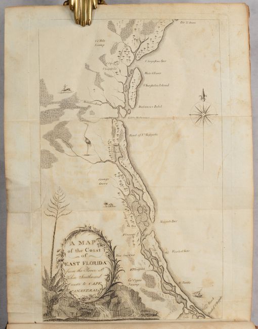
Auction 199, Lot 156
Subject: Southeastern United States
Bartram, William
Travels Through North & South Carolina, Georgia, East & West Florida, the Cherokee Country, the Extensive Territories of the Muscogulges, or Creek Confederacy, and the Country of the Chactaws..., 1791
Size: 5.9 x 9.8 inches (15 x 24.9 cm)
Estimate: $9,500 - $11,000
Complete First Edition of Bartram's Work on the American Southeast
Unsold
Closed on 9/11/2024
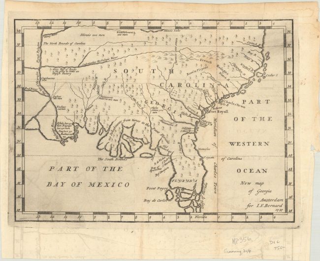
Auction 199, Lot 161
Subject: Colonial Southern United States
Bernard, Jean Frederic
New Map of Georgia, 1737
Size: 10.3 x 7.5 inches (26.2 x 19.1 cm)
Estimate: $1,400 - $1,700
One of the Earliest Published Maps of the English Colony of Georgia
Sold for: $1,000
Closed on 9/11/2024
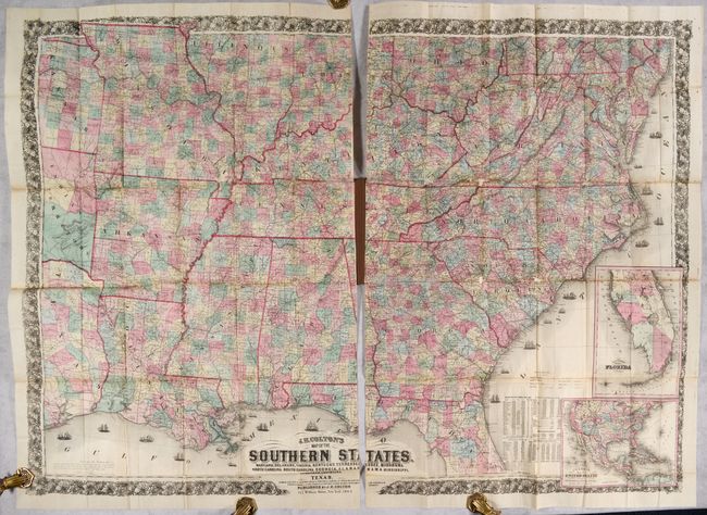
Auction 199, Lot 163
Subject: Southern United States, Civil War
Colton, Joseph Hutchins
J.H. Colton's Map of the Southern States. Maryland, Delaware, Virginia, Kentucky, Tennessee, Missouri, North Carolina, South Carolina, Georgia, Alabama, Mississippi, Arkansas, Louisiana and Texas..., 1864
Size: 52.7 x 38 inches (133.9 x 96.5 cm)
Estimate: $2,400 - $3,000
Large-Scale Map of the South Issued During the Civil War
Unsold
Closed on 9/11/2024
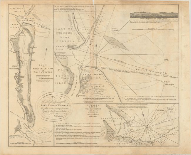
Auction 199, Lot 212
Subject: Amelia Island, Florida
Jefferys, Thomas
A Chart of the Entrance into St. Mary's River Taken by Captn. W. Fuller in November 1769 [on sheet with] Plan of Amelia Island in East Florida [and] A Chart of the Mouth of Nassau River... , 1770
Size: 24.1 x 20 inches (61.2 x 50.8 cm)
Estimate: $2,750 - $3,500
Price Reduced by $600! Important Charts Detailing Amelia Island and Surrounding Rivers
Unsold
Closed on 9/11/2024
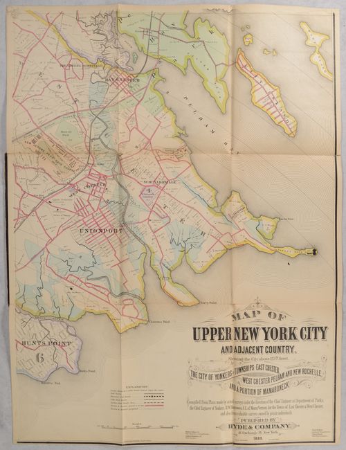
Auction 199, Lot 251
Subject: New York City, New York
[On 4 Sheets] Map of Upper New York City and Adjacent Country. Showing the City Above 125th Street. The City of Yonkers and Townships of East Chester..., 1889
Size: 23.3 x 31 inches (59.2 x 78.7 cm)
Estimate: $1,200 - $1,500
Elaborate 4-Sheet Map of Upper New York City and Westchester County
Unsold
Closed on 9/11/2024
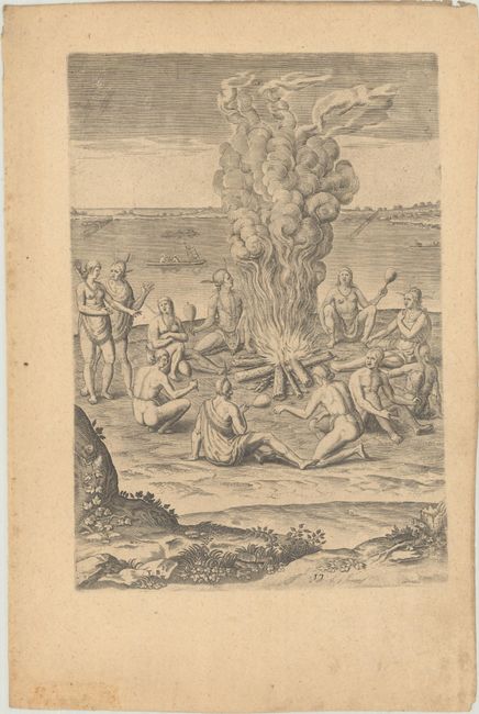
Auction 199, Lot 279
Subject: Virginia, Native Americans
Bry, Theodore de
[Grands Voyages, Part I] Admiranda Narratio Fida Tamen, de Commodis et Incolarum Ritibus Virginiae, Nuper Admodum ab Anglis..., 1608
Size: 9.5 x 13.3 inches (24.1 x 33.8 cm)
Estimate: $1,900 - $2,200
Set of De Bry's Native Virginians & Picts from Part I of Grands Voyages
Sold for: $3,000
Closed on 9/11/2024
18 lots