Showing Featured Lots(remove filter)
Filtered by Category:United States(Show All Categories)
Showing results for:Auction 198
Catalog Archive
17 lots
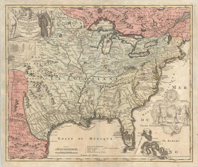
Auction 198, Lot 90
Subject: Colonial Eastern United States & Canada
Homann, Johann Baptist
Amplissimae Regionis Mississipi seu Provinciae Ludovicianae a R.P. Ludovico Hennepin Francisc Miss in America Septentrionali Anno 1687..., 1720
Size: 23 x 19.4 inches (58.4 x 49.3 cm)
Estimate: $2,000 - $2,300
Striking Map of Colonial America with Bison Vignette
Sold for: $1,500
Closed on 6/19/2024
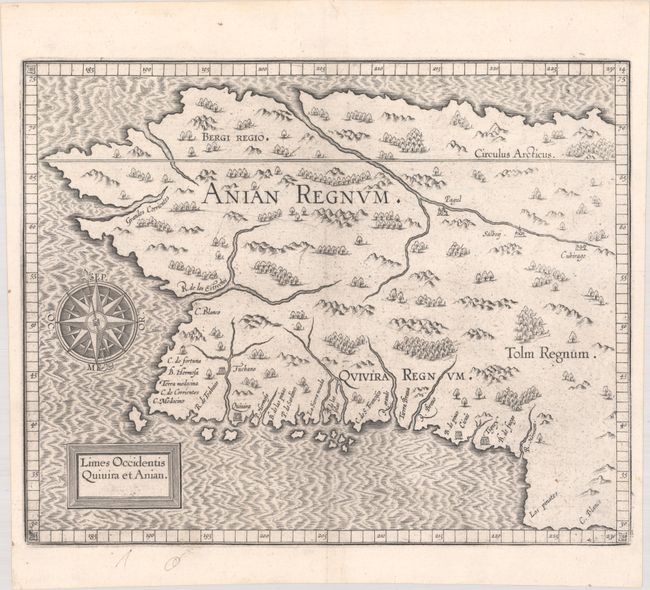
Auction 198, Lot 95
Subject: Alaska & Western Canada
Wytfliet, Cornelis
Limes Occidentis Quivira et Anian, 1607
Size: 11.6 x 9.3 inches (29.5 x 23.6 cm)
Estimate: $1,800 - $2,200
Early and Imaginary Map of Alaska and the Northwest Passage
Sold for: $1,000
Closed on 6/19/2024
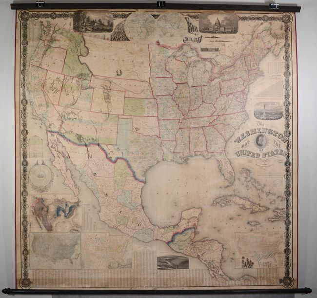
Auction 198, Lot 104
Subject: United States
Maury, M. F.
The Washington Map of the United States, 1861
Size: 68 x 67 inches (172.7 x 170.2 cm)
Estimate: $2,000 - $2,500
Taintor Edition of Maury's Spectacular Wall Map
Sold for: $2,100
Closed on 6/19/2024
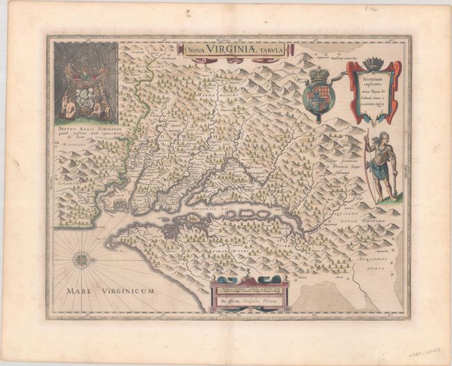
Auction 198, Lot 122
Subject: Colonial Mid-Atlantic United States
Hondius/Blaeu
Nova Virginiae Tabula, 1642
Size: 18.9 x 14.8 inches (48 x 37.6 cm)
Estimate: $1,900 - $2,200
One of the Most Important 17th Century Maps of the Chesapeake Bay in Full Contemporary Color
Sold for: $1,250
Closed on 6/19/2024
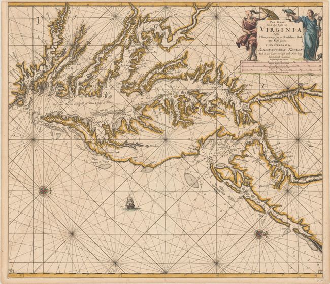
Auction 198, Lot 123
Subject: Colonial Chesapeake & Delaware Bays
Keulen, Johannes van
Pas Kaart van de Zee Kusten van Virginia Tusschen C Henry en t Hooge Land van Renselaars Hoek, 1695
Size: 23.1 x 20.3 inches (58.7 x 51.6 cm)
Estimate: $4,000 - $4,750
One of the Earliest Maps to Show Philadelphia
Sold for: $3,500
Closed on 6/19/2024
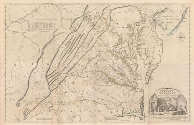
Auction 198, Lot 125
Subject: Colonial Mid-Atlantic United States, Virginia
Fry, Joshua & Jefferson, Peter
[On 4 Sheets] A Map of the Most Inhabited Part of Virginia Containing the Whole Province of Maryland with Part of Pensilvania, New Jersey and North Carolina, 1775
Size: 48.4 x 15.7 inches (122.9 x 39.9 cm)
Estimate: $15,000 - $18,000
1775 Edition of the Landmark Fry-Jefferson Map of Virginia and Maryland
Sold for: $11,000
Closed on 6/19/2024
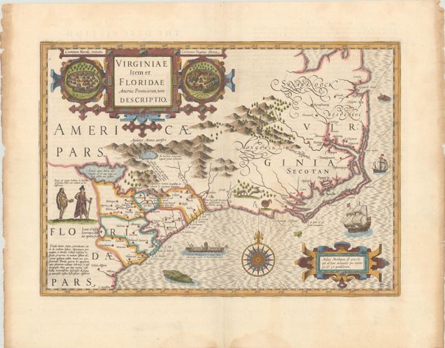
Auction 198, Lot 127
Subject: Colonial Southeastern United States
Mercator/Hondius
Virginiae Item et Floridae Americae Provinciarum, Nova Descriptio, 1636
Size: 19.1 x 13.6 inches (48.5 x 34.5 cm)
Estimate: $2,000 - $2,300
A Seminal Map of the Southeast and Early American Cartography with English Text
Sold for: $1,700
Closed on 6/19/2024
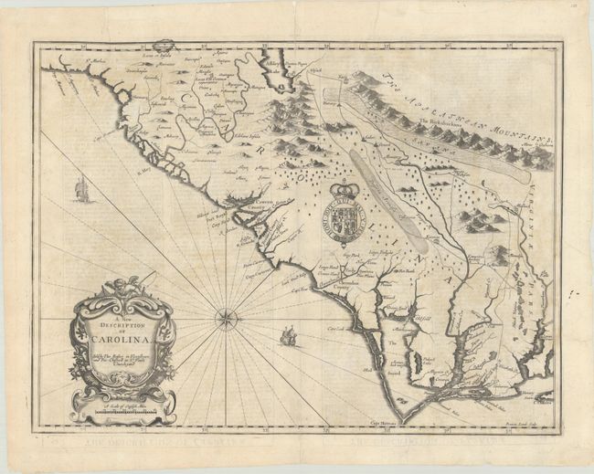
Auction 198, Lot 128
Subject: Colonial Southeastern United States
Speed/Lamb
A New Description of Carolina, 1676
Size: 19.8 x 14.8 inches (50.3 x 37.6 cm)
Estimate: $2,400 - $3,000
Speed's Map of the Carolinas Based Upon the Lords Proprietor's Map
Unsold
Closed on 6/19/2024
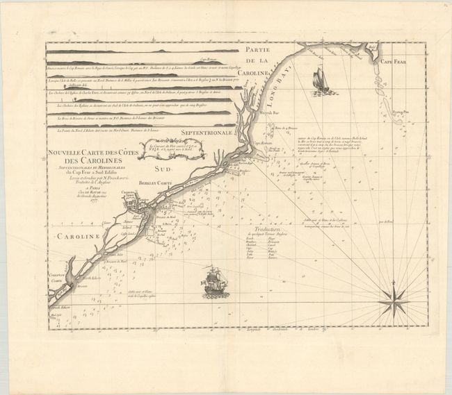
Auction 198, Lot 132
Subject: Colonial Southeastern United States
Le Rouge, George Louis
Nouvelle Carte des Cotes des Carolines Septentrionales et Meridionales du Cap Fear a Sud Edisto..., 1777
Size: 21.3 x 16.1 inches (54.1 x 40.9 cm)
Estimate: $1,400 - $1,700
Rare French Chart of the Carolina Coast
Unsold
Closed on 6/19/2024
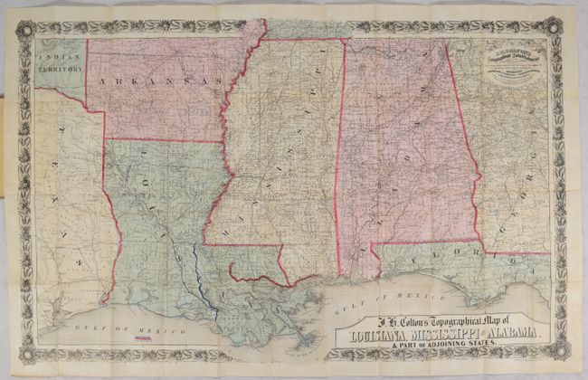
Auction 198, Lot 133
Subject: Southeastern United States, Civil War
Colton, Joseph Hutchins
J.H. Colton's Topographical Map of Louisiana, Mississippi and Alabama. & Part of Adjoining States, 1864
Size: 31.4 x 19.8 inches (79.8 x 50.3 cm)
Estimate: $1,000 - $1,500
Civil War Era Pocket Map with Manuscript Additions
Sold for: $575
Closed on 6/19/2024
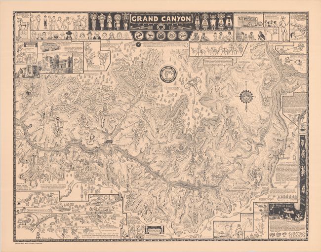
Auction 198, Lot 159
Subject: Grand Canyon, Arizona
Mora, Joseph Jacinto
Grand Canyon, 1931
Size: 25.9 x 20.3 inches (65.8 x 51.6 cm)
Estimate: $1,200 - $1,500
Original Printing of Jo Mora's Classic Pictorial Map of the Grand Canyon
Sold for: $850
Closed on 6/19/2024
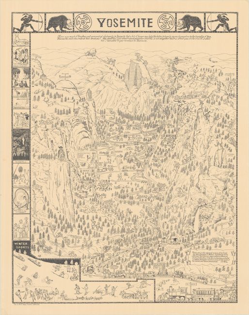
Auction 198, Lot 164
Subject: Yosemite, California
Mora, Joseph Jacinto
Yosemite, 1931
Size: 20.1 x 25.8 inches (51.1 x 65.5 cm)
Estimate: $1,200 - $1,500
Original Printing of Jo Mora's Classic Pictorial Map of Yosemite
Sold for: $1,200
Closed on 6/19/2024
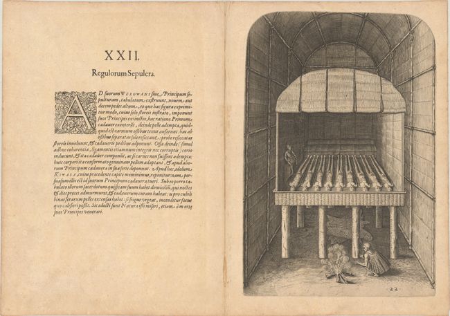
Auction 198, Lot 190
Subject: Florida, Natives
Bry, Theodore de
[Grands Voyages, Part II] Der Ander Theil / der Newlich Erfundenen Landtschafft Americae, von Dreyen Schiffahrten / so die Frantzosen in Floridam..., 1603
Size: 9.1 x 13.4 inches (23.1 x 34 cm)
Estimate: $2,400 - $3,000
Text and Native Floridian Plates from Part II of Grands Voyages
Sold for: $2,750
Closed on 6/19/2024
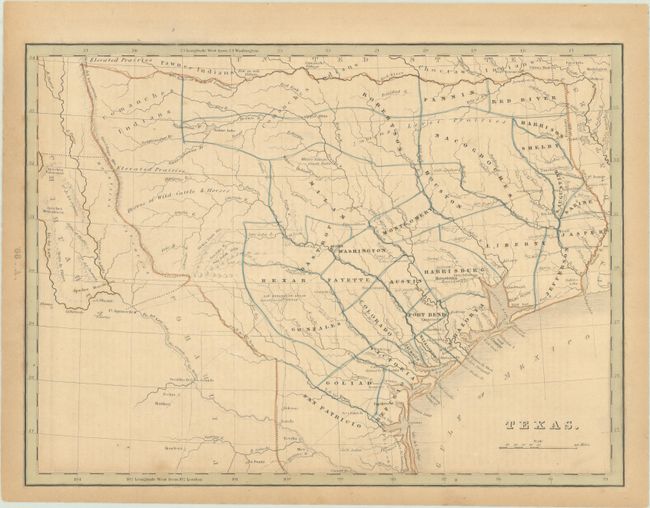
Auction 198, Lot 246
Subject: Republic of Texas
Bradford, Thomas Gamaliel
Texas, 1843
Size: 10.5 x 7.8 inches (26.7 x 19.8 cm)
Estimate: $1,500 - $1,800
Bradford's Map of Texas Showing Early Counties Instead of Land Grants
Sold for: $1,300
Closed on 6/19/2024
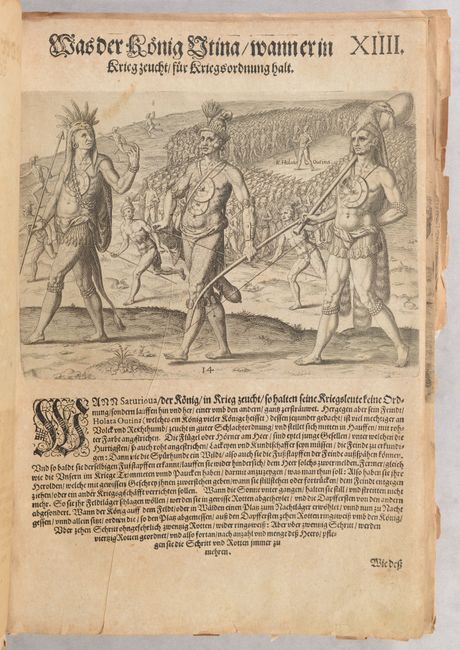
Auction 198, Lot 258
Subject: Virginia, Native Americans
Bry, Theodore de
[Grands Voyages, Part I - 27 Plates of Virginia Natives & Picts], 1608
Size: 9.4 x 12.9 inches (23.9 x 32.8 cm)
Estimate: $2,750 - $3,500
Complete Set of De Bry's Native Virginians & Picts from Part I of Grands Voyages
Sold for: $4,000
Closed on 6/19/2024
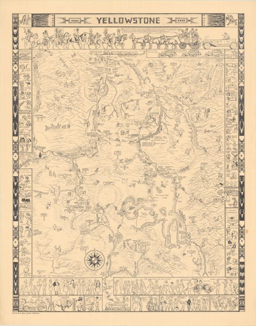
Auction 198, Lot 260
Subject: Yellowstone National Park, Wyoming
Mora, Joseph Jacinto
Yellowstone, 1931
Size: 20.1 x 25.8 inches (51.1 x 65.5 cm)
Estimate: $1,200 - $1,500
Original Printing of Jo Mora's Classic Pictorial Map of Yellowstone
Sold for: $850
Closed on 6/19/2024
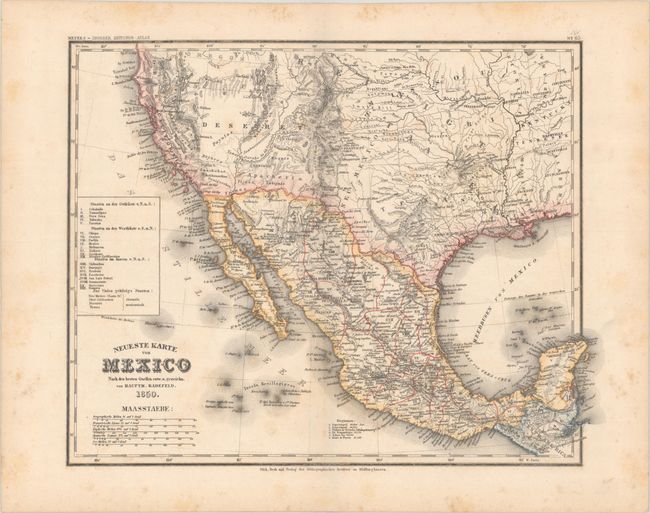
Auction 198, Lot 261
Subject: United States & Mexico
Radefeld, Carl Christian Franz
Neueste Karte von Mexico nach den Besten Quellen..., 1850
Size: 14.8 x 11.6 inches (37.6 x 29.5 cm)
Estimate: $750 - $900
Rare Map Showing The Proposed State of Deseret
Sold for: $500
Closed on 6/19/2024
17 lots