Showing Featured Lots(remove filter)
Showing results for:Auction 202
Catalog Archive
55 lots
Page 1 of 2
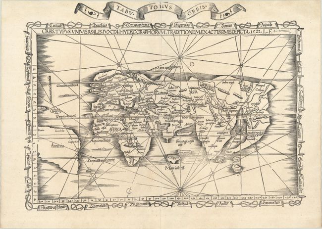
Auction 202, Lot 1
Subject: World
Waldseemuller/Fries
Orbis Typus Universalis Iuxta Hydrographorum Traditionem Exactissime Depicta, 1522
Size: 18.9 x 13.9 inches (48 x 35.3 cm)
Estimate: $6,000 - $7,500
One of the First Ptolemaic Maps to Name America
Sold for: $5,500
Closed on 2/12/2025
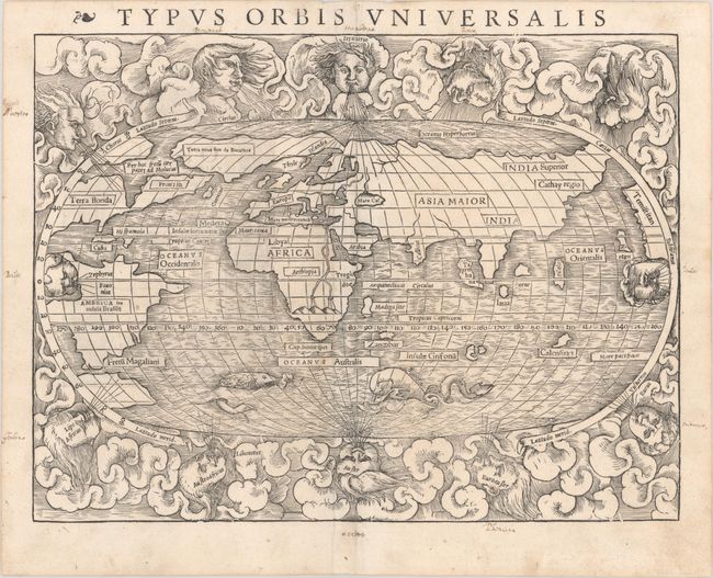
Auction 202, Lot 2
Subject: World
Munster, Sebastian
Typus Orbis Universalis, 1540
Size: 13.5 x 10.2 inches (34.3 x 25.9 cm)
Estimate: $5,500 - $6,500
Rare First Block of Munster's World Map - First Edition
Sold for: $6,000
Closed on 2/12/2025
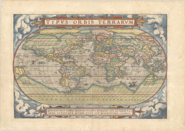
Auction 202, Lot 3
Subject: World
Ortelius, Abraham
Typus Orbis Terrarum, 1571
Size: 19.4 x 13.3 inches (49.3 x 33.8 cm)
Estimate: $7,000 - $8,500
Ortelius' Famous World Map - First Plate
Sold for: $7,500
Closed on 2/12/2025
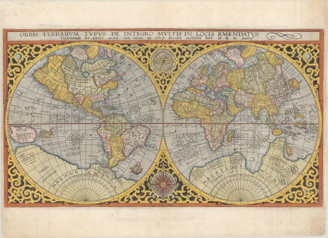
Auction 202, Lot 5
Subject: World
Plancius, Petrus
Orbis Terrarum Typus de Integro Multis in Locis Emendatus..., 1624
Size: 20.1 x 11.3 inches (51.1 x 28.7 cm)
Estimate: $2,750 - $3,500
Plancius' World Map Surrounded by Elegant Strapwork
Sold for: $2,300
Closed on 2/12/2025
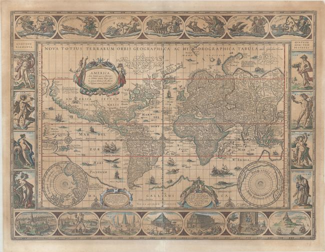
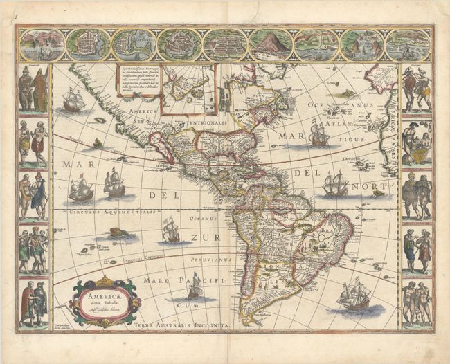
Auction 202, Lot 6
Subject: World
Blaeu, Willem
Nova Totius Terrarum Orbis Geographica ac Hydrographica Tabula, 1635
Size: 21.3 x 16.1 inches (54.1 x 40.9 cm)
Estimate: $10,000 - $12,000
Blaeu's Magnificent Carte-a-Figures World Map
Unsold
Closed on 2/12/2025
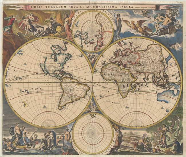
Auction 202, Lot 9
Subject: World
Visscher, Nicolas
Orbis Terrarum Nova et Accuratissima Tabula, 1658
Size: 21.8 x 18.4 inches (55.4 x 46.7 cm)
Estimate: $4,750 - $6,000
Visscher's Superb Double-Hemisphere World Map with Representations of the Elements
Sold for: $5,500
Closed on 2/12/2025
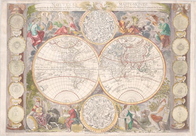
Auction 202, Lot 18
Subject: World
Bailleul, Nicolas
Nouvelle Mappe-Monde avec la Representation des Deux Emispheres Celestes, les Disques du Soleil, et de la Lune, et les Diferents Sentiments sur le Mouvemt. des Planetes..., 1755
Size: 28.8 x 20.6 inches (73.2 x 52.3 cm)
Estimate: $4,000 - $5,000
Map Featuring Interesting Cartography in the Northwest
Sold for: $4,250
Closed on 2/12/2025
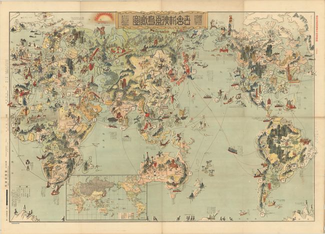
Auction 202, Lot 29
Subject: World
[Japanese Manga World Map - New Cartoon View of the World], 1924
Size: 41.6 x 28.3 inches (105.7 x 71.9 cm)
Estimate: $2,400 - $3,000
Fascinating Japanese Satirical Map Published After WWI
Sold for: $1,400
Closed on 2/12/2025
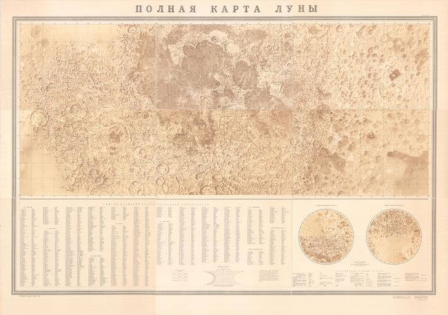
Auction 202, Lot 48
Subject: Moon
[On 9 Sheets - Polnaya Karta Luny], 1967
Size: 26.5 x 17.3 inches (67.3 x 43.9 cm)
Estimate: $700 - $900
Spectacular 9-Sheet Soviet Lunar Map
Sold for: $550
Closed on 2/12/2025

Auction 202, Lot 57
Subject: Cartographic Miscellany, Internet
Road Map to the World Wide Web - The World Wide Web Business and Beyond, 1995
Size: 36.5 x 24 inches (92.7 x 61 cm)
Estimate: $1,400 - $1,800
Scarce Map of the Early World Wide Web
Unsold
Closed on 2/12/2025
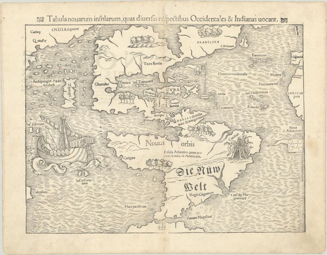
Auction 202, Lot 58
Subject: Western Hemisphere - America
Munster, Sebastian
Tabula Novarum Insnlarum, quas Diversis Respectibus Occidentales & Indianas Vocant, 1554
Size: 13.6 x 10.2 inches (34.5 x 25.9 cm)
Estimate: $5,000 - $6,000
One of the Most Important 16th Century Maps of the New World
Sold for: $5,500
Closed on 2/12/2025
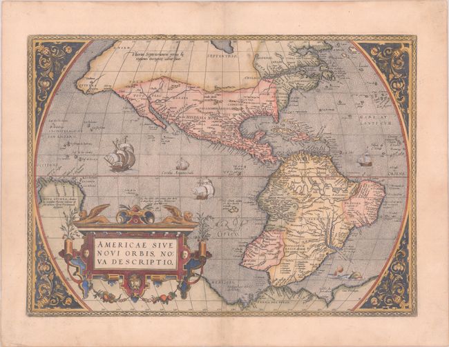
Auction 202, Lot 59
Subject: Western Hemisphere - America
Ortelius, Abraham
Americae sive Novi Orbis, Nova Descriptio, 1575
Size: 20.1 x 14.6 inches (51.1 x 37.1 cm)
Estimate: $5,500 - $7,000
Rare First Plate of Ortelius' Influential Map of the New World
Sold for: $5,500
Closed on 2/12/2025
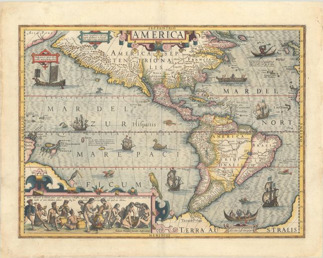
Auction 202, Lot 60
Subject: Western Hemisphere - America
Hondius, Jodocus
America, 1609
Size: 19.8 x 14.8 inches (50.3 x 37.6 cm)
Estimate: $4,750 - $6,000
Hondius' Important Map of the Americas
Sold for: $4,250
Closed on 2/12/2025
Auction 202, Lot 61
Subject: Western Hemisphere - America
Blaeu, Willem
Americae Nova Tabula, 1634
Size: 22 x 16.3 inches (55.9 x 41.4 cm)
Estimate: $4,000 - $4,750
Blaeu's Stunning Carte-a-Figures Map of the Americas
Sold for: $3,000
Closed on 2/12/2025
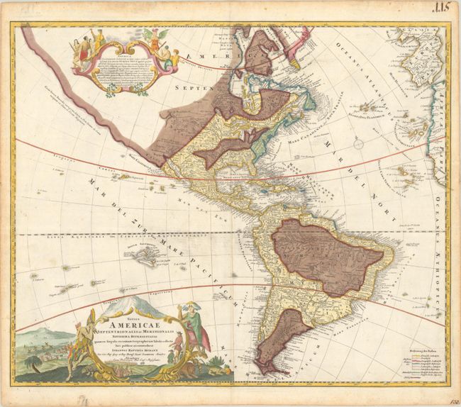
Auction 202, Lot 65
Subject: Western Hemisphere - America
Homann, Johann Baptist
Totius Americae Septentrionalis et Meridionalis Novissima Repraesentatio quam ex Singulis Recentium Geographorum Tabulis Collecta Luci Publicae Accommodavit, 1740
Size: 23.1 x 19.1 inches (58.7 x 48.5 cm)
Estimate: $700 - $850
Unique Thematic Edition Depicting Religions
Sold for: $500
Closed on 2/12/2025
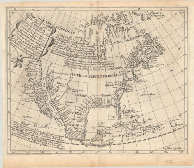
Auction 202, Lot 73
Subject: Colonial North America
Briggs, Henry
The North Part of America Conteyning Newfoundland, New England, Virginia, Florida, New Spaine, and Nova Francia..., 1625
Size: 13.9 x 11.3 inches (35.3 x 28.7 cm)
Estimate: $16,000 - $19,000
First English Map to Show California as an Island
Sold for: $11,500
Closed on 2/12/2025
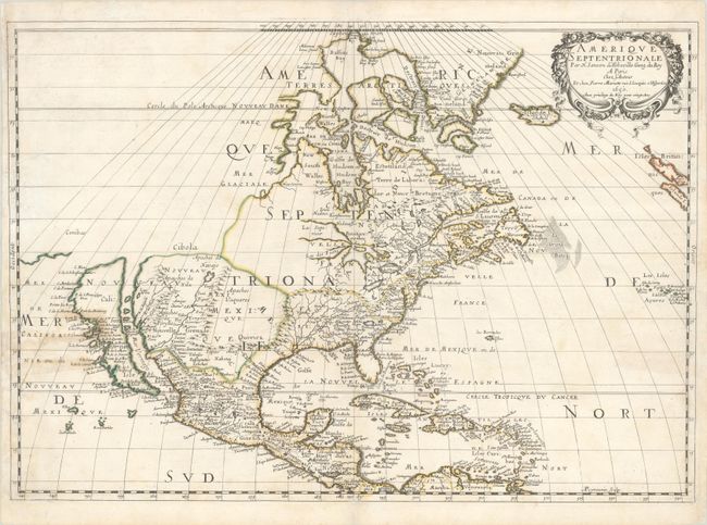
Auction 202, Lot 74
Subject: Colonial North America
Sanson/Mariette
Amerique Septentrionale par N. Sanson d'Abbeville…, 1650
Size: 21.8 x 15.4 inches (55.4 x 39.1 cm)
Estimate: $3,500 - $4,250
Important Map for Great Lakes Collectors
Sold for: $2,500
Closed on 2/12/2025
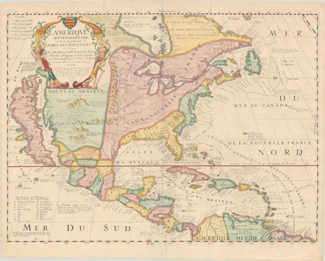
Auction 202, Lot 75
Subject: Colonial North America
Coronelli/Nolin
L'Amerique Septentrionale, ou la Partie Septentrionale des Indes Occidentales ou se Trouve le Canada ou Nouvelle France la Floride la Virginie les Isles Antilles le Nouveau Mexique et la Nouvele. Espagne..., 1704
Size: 23.7 x 18 inches (60.2 x 45.7 cm)
Estimate: $3,000 - $3,750
Nolin's Spectacular Version of Coronelli's Map of North America
Sold for: $4,250
Closed on 2/12/2025
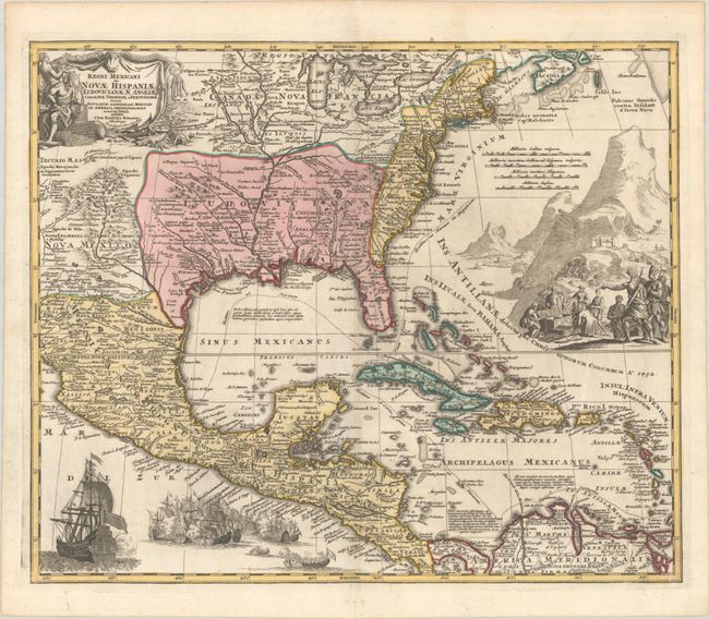
Auction 202, Lot 88
Subject: Colonial Eastern North America & West Indies
Homann, Johann Baptist
Regni Mexicani seu Novae Hispaniae, Ludovicianae, N. Angliae, Carolinae, Virginiae, et Pensylvaniae, nec non Insularum Archipelagi Mexicani in America Septentrionali Accurata Tabula, 1720
Size: 22.6 x 18.9 inches (57.4 x 48 cm)
Estimate: $1,600 - $1,900
Homann's Decorative Map of Colonial America in the Era of the War of the Spanish Succession
Sold for: $1,500
Closed on 2/12/2025
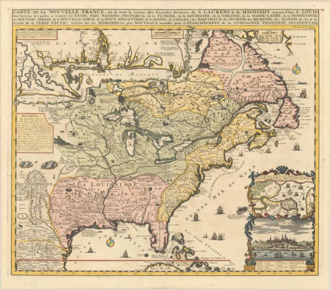
Auction 202, Lot 102
Subject: Colonial Eastern United States & Canada
Chatelain, Henry Abraham
Carte de la Nouvelle France, ou se voit les Cours des Grandes Rivieres de S. Laurens & de Mississipi Aujour d'hui S. Louis, aux Environs des quelles se Trouvent les Etats, Pais, Nations, Peuples &c. de la Floride, de la Louisiane, de la Virginie..., 1719
Size: 19 x 16.5 inches (48.3 x 41.9 cm)
Estimate: $3,000 - $3,750
One of the Most Informative 18th Century Maps of the French Possessions in North America
Sold for: $2,000
Closed on 2/12/2025
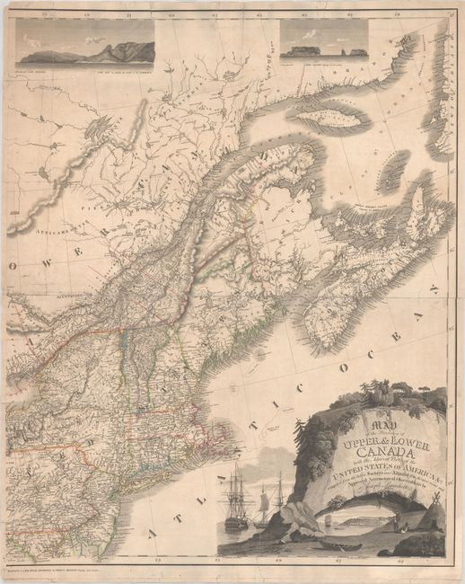
Auction 202, Lot 106
Subject: Northeastern United States & Canada
Bouchette, Joseph
[Eastern Sheet] Map of the Provinces of Upper & Lower Canada with the Adjacent Parts of the United States of America &c. Compiled from the Latest Surveys and Adjusted from the Most Recent and Approved Astronomical Observations, 1815
Size: 24.3 x 30 inches (61.7 x 76.2 cm)
Estimate: $2,750 - $3,500
Eastern Sheet of Bouchette's Rare Map Presenting Lower Canada and New England
Unsold
Closed on 2/12/2025
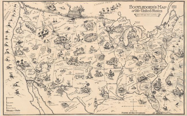
Auction 202, Lot 118
Subject: United States
Bootlegger's Map of the United States, 1926
Size: 33.9 x 21.3 inches (86.1 x 54.1 cm)
Estimate: $1,100 - $1,400
McCandlish's Humorous Prohibition Map
Sold for: $900
Closed on 2/12/2025
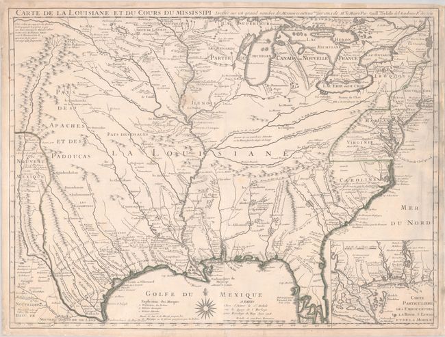
Auction 202, Lot 122
Subject: Colonial Eastern United States
Delisle, Guillaume
Carte de la Louisiane et du Cours du Mississipi Dressee sur un Grand Nombre de Memoires Entrau'tres sur ceux de Mr. le Maire, 1718
Size: 25.7 x 19.3 inches (65.3 x 49 cm)
Estimate: $4,750 - $6,000
A Foundation Map for the Mississippi Valley and the First Appearance of Texas on a Printed Map - First Issue
Sold for: $2,650
Closed on 2/12/2025
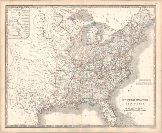
Auction 202, Lot 128
Subject: Eastern United States, Texas
Johnston, Alexander K.
United States and Texas, 1842
Size: 24.3 x 19.8 inches (61.7 x 50.3 cm)
Estimate: $1,200 - $1,500
Scottish Atlas Map Featuring the Independent Republic of Texas
Sold for: $900
Closed on 2/12/2025
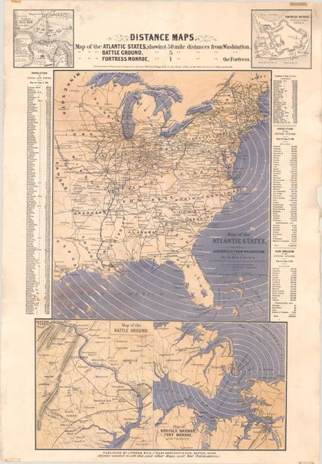
Auction 202, Lot 130
Subject: Eastern United States, Civil War
Prang, Louis
Distance Maps. Map of the Atlantic States Showing 50 Mile Distances from Washington..., 1861
Size: 15 x 22.1 inches (38.1 x 56.1 cm)
Estimate: $1,100 - $1,400
Rare Civil War Distance Map
Sold for: $650
Closed on 2/12/2025
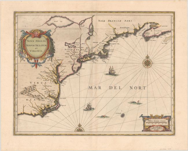
Auction 202, Lot 134
Subject: Colonial New England & Mid-Atlantic United States
Jansson, Jan
Nova Anglia Novum Belgium et Virginia, 1639
Size: 19.8 x 15.3 inches (50.3 x 38.9 cm)
Estimate: $1,200 - $1,500
First State of Jansson's Influential Map of the East Coast
Sold for: $700
Closed on 2/12/2025
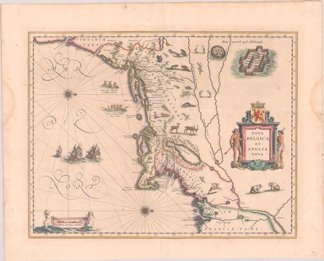
Auction 202, Lot 135
Subject: Colonial New England & Mid-Atlantic United States
Blaeu, Willem
Nova Belgica et Anglia Nova, 1640
Size: 19.8 x 15.3 inches (50.3 x 38.9 cm)
Estimate: $1,900 - $2,200
Important Map of Colonial New England and the Mid-Atlantic in Full Contemporary Color
Sold for: $1,400
Closed on 2/12/2025
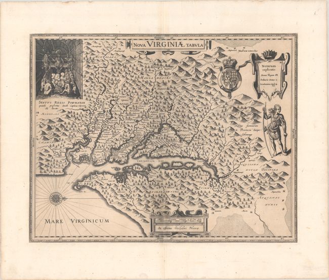
Auction 202, Lot 147
Subject: Colonial Mid-Atlantic United States
Hondius/Blaeu
Nova Virginiae Tabula, 1630
Size: 19.1 x 14.9 inches (48.5 x 37.8 cm)
Estimate: $1,400 - $1,700
One of the Most Important 17th Century Maps of the Chesapeake Bay
Sold for: $1,000
Closed on 2/12/2025
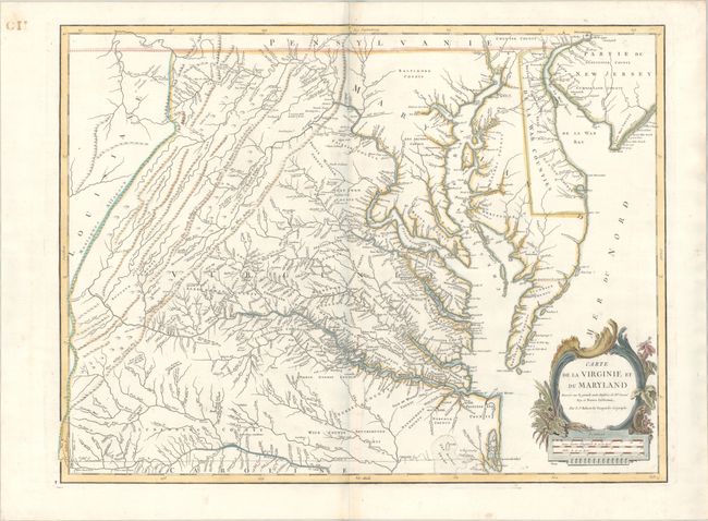
Auction 202, Lot 154
Subject: Mid-Atlantic United States
Robert de Vaugondy, Didier
Carte de la Virginie et du Maryland Dressee sur la Grande Carte Angloise de Mrs. Josue Fry et Pierre Jefferson, 1793
Size: 25.3 x 19 inches (64.3 x 48.3 cm)
Estimate: $1,400 - $1,700
An Essential Map of Virginia and Maryland
Sold for: $1,000
Closed on 2/12/2025

Auction 202, Lot 156
Subject: Mid-Atlantic United States, Civil War
Bachmann, John
Panorama of the Seat of War. Birds Eye View of Virginia, Maryland Delaware and the District of Columbia, 1861
Size: 28.1 x 18.1 inches (71.4 x 46 cm)
Estimate: $1,800 - $2,200
Bachmann's Dramatic View of the Mid-Atlantic Region
Sold for: $1,700
Closed on 2/12/2025
Auction 202, Lot 158
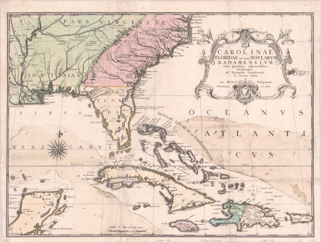
Subject: Colonial Southeastern United States, Bahamas & Greater Antilles
Seligmann, Johann Michael
Carolinae Floridae nec non Insularum Bahamensium cum Partibus Adjacendibus Delineatio ad Exemplar Londinense in Lucem Edita, 1755
Size: 23 x 17 inches (58.4 x 43.2 cm)
Estimate: $3,250 - $4,000
German Edition of Catesby's Scarce and Important Map of the Southeastern United States
Sold for: $2,400
Closed on 2/12/2025
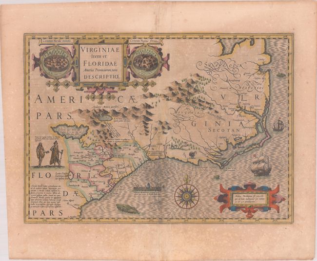
Auction 202, Lot 159
Subject: Colonial Southeastern United States
Hondius, Jodocus
Virginiae Item et Floridae Americae Provinciarum, Nova Descriptio, 1619
Size: 19.1 x 13.5 inches (48.5 x 34.3 cm)
Estimate: $1,400 - $1,700
A Seminal Map of the Southeast and Early American Cartography in Full Contemporary Color
Unsold
Closed on 2/12/2025
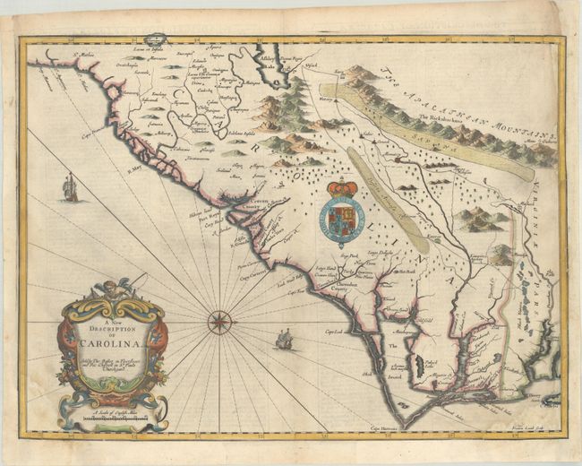
Auction 202, Lot 161
Subject: Colonial Southeastern United States
Speed/Lamb
A New Description of Carolina, 1676
Size: 20 x 14.9 inches (50.8 x 37.8 cm)
Estimate: $2,200 - $2,500
Speed's Map of the Carolinas Based Upon the Lords Proprietor's Map
Unsold
Closed on 2/12/2025
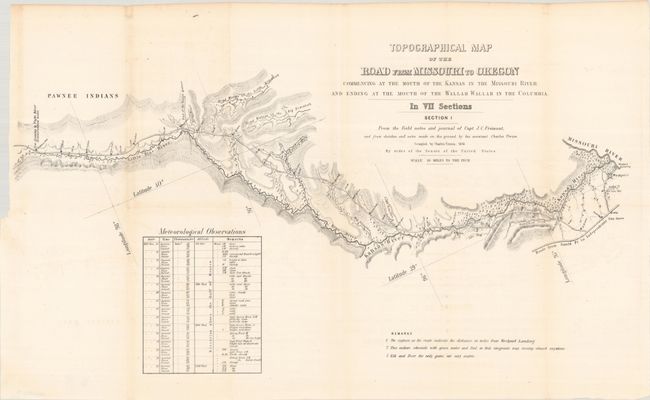
Auction 202, Lot 179
Subject: Western United States
Fremont/Preuss
[Lot of 7] Topographical Map of the Road from Missouri to Oregon Commencing at the Mouth of the Kansas in the Missouri River...In VII Sections... [with] Report No. 145...Canal or Railroad Between the Atlantic and Pacific Oceans, 1849
Size: 24.5 x 12.8 inches (62.2 x 32.5 cm)
Estimate: $3,000 - $3,750
Scarce Seven-Part Oregon Trail Map
Sold for: $3,000
Closed on 2/12/2025
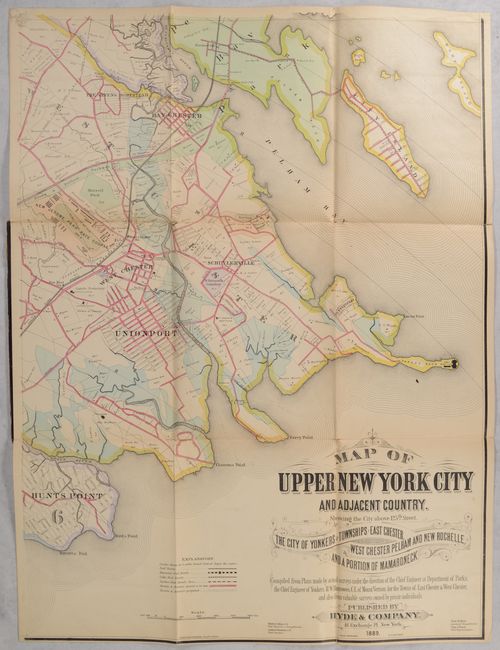
Auction 202, Lot 240
Subject: New York City, New York
[On 4 Sheets] Map of Upper New York City and Adjacent Country. Showing the City Above 125th Street. The City of Yonkers and Townships of East Chester..., 1889
Size: 23.3 x 31 inches (59.2 x 78.7 cm)
Estimate: $900 - $1,100
Elaborate 4-Sheet Map of Upper New York City and Westchester County
Sold for: $650
Closed on 2/12/2025

Auction 202, Lot 261
Subject: Documents - Texas Independence
[Texas Independence] Niles' Weekly Register ... from March, 1836, to September, 1836..., 1836
Size: 6.4 x 9.8 inches (16.3 x 24.9 cm)
Estimate: $750 - $900
Texas Independence and Much More
Sold for: $550
Closed on 2/12/2025
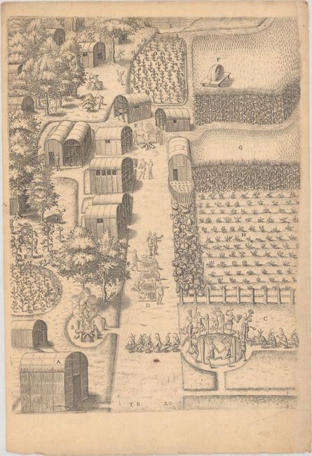
Auction 202, Lot 262
Subject: Virginia, Native Americans
Bry, Theodore de
[Grands Voyages, Part I] Admiranda Narratio Fida Tamen, de Commodis et Incolarum Ritibus Virginiae, Nuper Admodum ab Anglis..., 1608
Size: 9.1 x 13.7 inches (23.1 x 34.8 cm)
Estimate: $2,000 - $2,400
Set of De Bry's Native Virginians & Picts from Part I of Grands Voyages
Sold for: $2,500
Closed on 2/12/2025
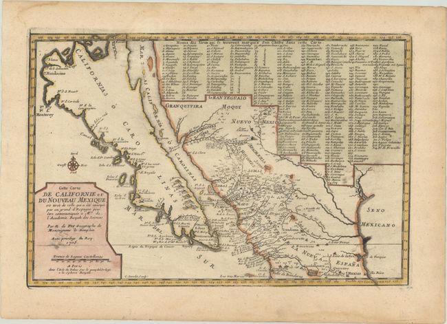
Auction 202, Lot 269
Subject: Southwestern United States & Mexico, California
Fer, Nicolas de
Cette Carte de Californie et du Nouveau Mexique, est Tiree de Celle qui a ete Envoyee par un Grand d'Espagne pour etre Communiquee a Mrs. de l'Academie Royale des Sciences, 1705
Size: 13.3 x 8.8 inches (33.8 x 22.4 cm)
Estimate: $1,000 - $1,300
De Fer's Important Map of the Island of California
Sold for: $750
Closed on 2/12/2025
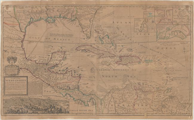
Auction 202, Lot 289
Subject: Gulf of Mexico & Caribbean
Moll, Herman
A Map of the West-Indies or the Islands of America in the North Sea; with ye Adjacent Countries; Explaning What Belongs to Spain, England, France, Holland &c..., 1730
Size: 39.8 x 23.1 inches (101.1 x 58.7 cm)
Estimate: $1,400 - $1,700
Moll's Two-Sheet Map Showing Colonial Possessions with Large View of Mexico City
Sold for: $1,400
Closed on 2/12/2025
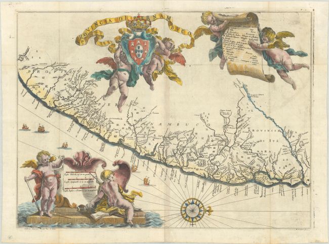
Auction 202, Lot 330
Subject: Eastern Brazil
Horatius, Andreas Antonius
Provincia di Pernambuco, 1698
Size: 19.9 x 14.8 inches (50.5 x 37.6 cm)
Estimate: $700 - $900
A Rare Map of Pernambuco from the "Santa Teresa"
Sold for: $700
Closed on 2/12/2025
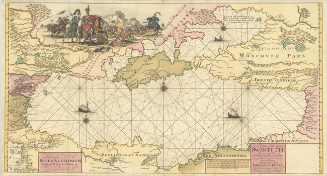
Auction 202, Lot 538
Subject: Black Sea
Keulen, Johannes van
Nieuwe Paskaart van de Geheele Swarte Zee Beginnende van Constantinopolen tot Azak..., 1709
Size: 38.6 x 20.8 inches (98 x 52.8 cm)
Estimate: $2,000 - $2,500
Rare Map of Black Sea with Vignette of Peter the Great's Azov Campaigns
Sold for: $6,000
Closed on 2/12/2025
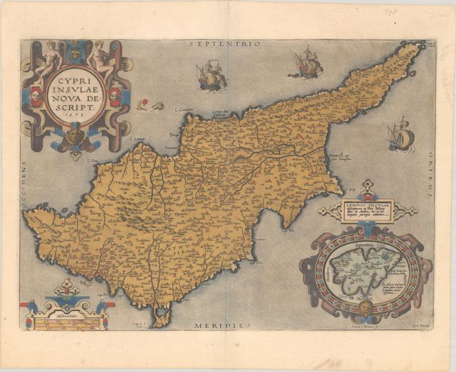
Auction 202, Lot 580
Subject: Cyprus
Ortelius, Abraham
Cypri Insulae Nova Descript., 1573
Size: 19.8 x 13.9 inches (50.3 x 35.3 cm)
Estimate: $1,200 - $1,500
Superb, Decorative Map of Cyprus in Full Contemporary Color
Unsold
Closed on 2/12/2025
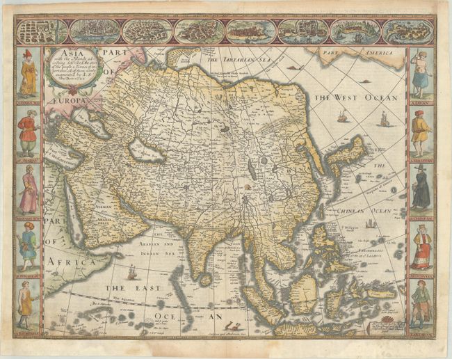
Auction 202, Lot 628
Subject: Asia
Speed, John
Asia with the Islands Adjoyning Described, the Atire of the People, & Townes of Importance, All of Them Newly Augmented, 1626
Size: 20.3 x 15.6 inches (51.6 x 39.6 cm)
Estimate: $2,000 - $2,300
The First English Printed Map of Asia
Sold for: $1,500
Closed on 2/12/2025
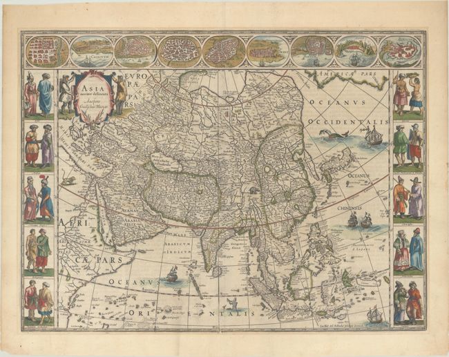
Auction 202, Lot 630
Subject: Asia
Blaeu, Willem
Asia Noviter Delineata, 1663
Size: 21.9 x 16.2 inches (55.6 x 41.1 cm)
Estimate: $3,250 - $4,000
Magnificent Carte-a-Figures Map of Asia in Full Contemporary Color
Unsold
Closed on 2/12/2025
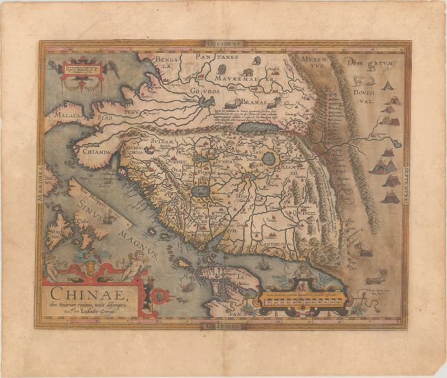
Auction 202, Lot 639
Subject: China
Ortelius, Abraham
Chinae, olim Sinarum Regionis, Nova Descriptio. Auctore Ludovico Georgio, 1584
Size: 18.7 x 14.5 inches (47.5 x 36.8 cm)
Estimate: $3,000 - $3,750
The First European-Printed Map of China in Full Contemporary Color
Unsold
Closed on 2/12/2025
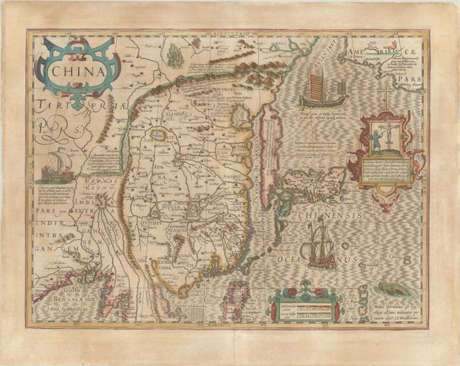
Auction 202, Lot 645
Subject: China, Korea & Japan
Mercator/Hondius
China, 1639
Size: 18.1 x 13.5 inches (46 x 34.3 cm)
Estimate: $2,000 - $2,300
Hondius' Map of China, Korea, and Japan in Full Contemporary Color
Sold for: $1,300
Closed on 2/12/2025
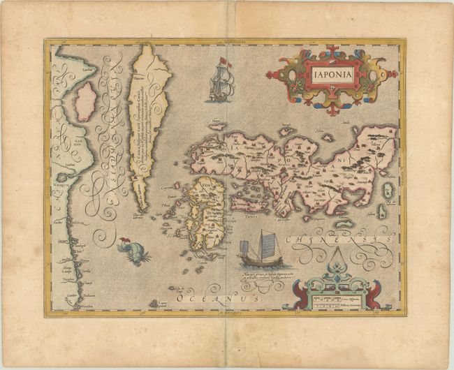
Auction 202, Lot 650
Subject: Japan & Korea
Mercator/Hondius
Iaponia, 1623
Size: 17.6 x 13.6 inches (44.7 x 34.5 cm)
Estimate: $1,100 - $1,400
Hondius' Richly Ornamented Map of Japan
Sold for: $750
Closed on 2/12/2025
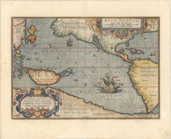
Auction 202, Lot 695
Subject: Pacific Ocean, Western Hemisphere
Ortelius, Abraham
Maris Pacifici, (quod Vulgo Mar del Zur) cum Regionibus Circumiacentibus, Insulisque in Eodem Passim Sparsis, Novissima Descriptio, 1589
Size: 19.7 x 13.6 inches (50 x 34.5 cm)
Estimate: $8,000 - $9,500
The First Printed Map Devoted to the Pacific
Sold for: $6,000
Closed on 2/12/2025
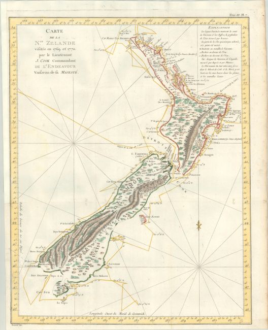
Auction 202, Lot 706
Subject: New Zealand
Cook/Benard
Carte de la Nle. Zelande Visitee en 1769 et 1770. Par le Lieutenant J. Cook Commandant de l'Endeavour Vaisseau de sa Majeste, 1774
Size: 14.8 x 18.8 inches (37.6 x 47.8 cm)
Estimate: $1,500 - $1,800
The First Complete Map of New Zealand
Sold for: $1,300
Closed on 2/12/2025

Auction 202, Lot 737
Subject: Early Printing
Hardouin, Gilles
[Book of Hours Leaf], 1518
Size: 4.6 x 7.1 inches (11.7 x 18 cm)
Estimate: $950 - $1,200
Superb Image of David Handing the Letter to Uriah in Contemporary Hand Color with Gilt Highlights
Sold for: $700
Closed on 2/12/2025
55 lots
Page 1 of 2