Showing Unsold Lots $100 to $250(remove filter)
Filtered by Category:United States(Show All Categories)
Current Auction
44 lots
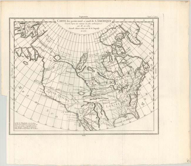
Lot 82
Subject: Colonial United States & Canada
Robert de Vaugondy, Didier
Carte des Parties Nord et Ouest de l Amerique Dresse d'Apres les Relations les Plus Authentiques par M... en 1764..., 1772
Size: 15 x 11.6 inches (38.1 x 29.5 cm)
Estimate: $200 - $230
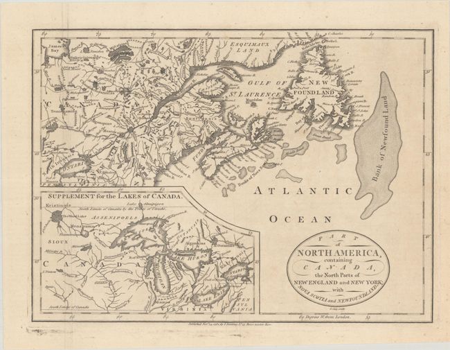
Lot 97
Subject: Colonial Northeastern United States & Canada, Great Lakes
Cary, John
Part of North America, Containing Canada, the North Parts of New England and New York; with Nova Scotia and Newfoundland, 1781
Size: 11.3 x 8.3 inches (28.7 x 21.1 cm)
Estimate: $190 - $220
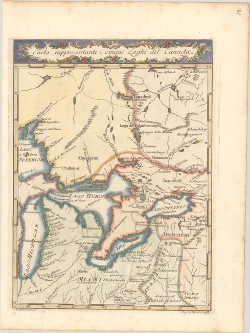
Lot 99
Subject: Colonial Central United States & Canada, Great Lakes
Pazzi, Giuseppe
Carta Rappresentante i Cinque Laghi del Canada, 1763
Size: 7.4 x 10 inches (18.8 x 25.4 cm)
Estimate: $240 - $300
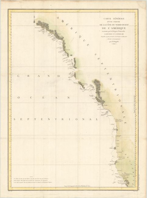
Lot 101
Subject: Western United States & Canada
La Perouse, Comte Jean F. Galoup, de
Carte Generale d'une Partie de la Cote du Nord-Ouest de l'Amerique Reconnue par les Fregates Francaises la Boussole et l'Astrolabe..., 1797
Size: 19.5 x 27.1 inches (49.5 x 68.8 cm)
Estimate: $200 - $230
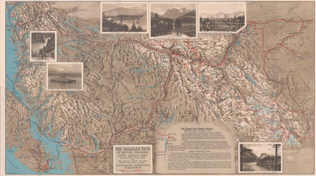
Lot 104
Subject: Northwestern United States & Canada
Railroad Companies, (Various)
The Triangle Tour of British Columbia - Jasper National Park Mount Robson Park Canadian Rockies and the Scenic Seas of the North Pacific Coast [on verso] Alaska and the Yukon, 1929
Size: 29.8 x 16.8 inches (75.7 x 42.7 cm)
Estimate: $150 - $180
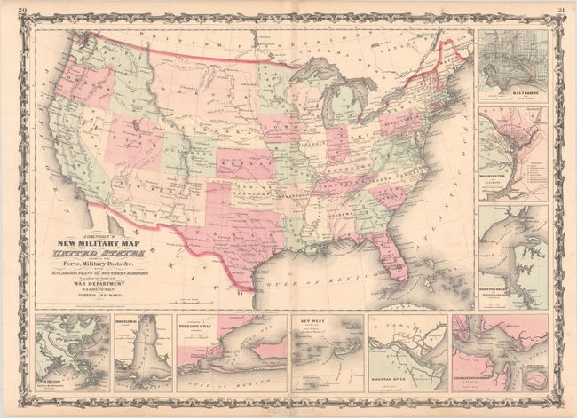
Lot 110
Subject: United States, Civil War
Johnson and Ward
Johnson's New Military Map of the United States Showing the Forts, Military Posts &c. With Enlarged Plans of Southern Harbors..., 1861
Size: 23.9 x 17.3 inches (60.7 x 43.9 cm)
Estimate: $240 - $300
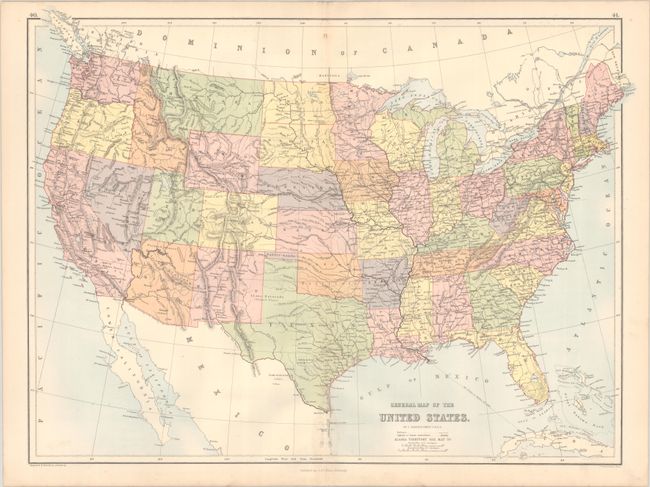
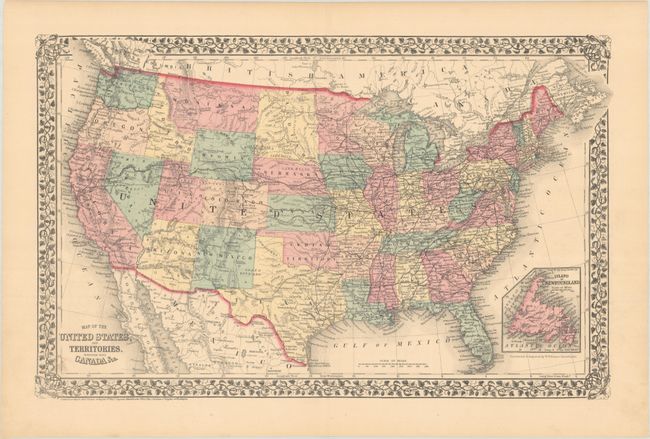
Lot 112
Subject: United States, Pembina
Bartholomew, John
General Map of the United States, 1875
Size: 22.3 x 16.6 inches (56.6 x 42.2 cm)
Estimate: $275 - $350
Scarce Map Depicting the Territory of Pembina
Lot 113
Subject: United States
Mitchell, Samuel Augustus
Map of the United States, and Territories. Together with Canada &c., 1876
Size: 21.5 x 13.6 inches (54.6 x 34.5 cm)
Estimate: $120 - $150
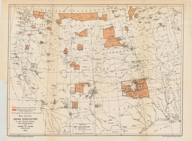
Lot 115
Subject: United States
U.S. Bureau of Indian Affairs
[Lot of 2] [Map with Report] Map Showing Indian Reservations in the United States West of the 84th Meridian... [with] Indian Reservations from the Public Domain [and] Map Showing Indian Reservations Within the Limits of the United States..., 1883-95
Size: See Description
Estimate: $275 - $350
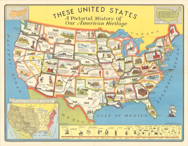
Lot 123
Subject: United States
These United States - A Pictorial History of Our American Heritage, 1949
Size: 34.6 x 26.4 inches (87.9 x 67.1 cm)
Estimate: $140 - $170
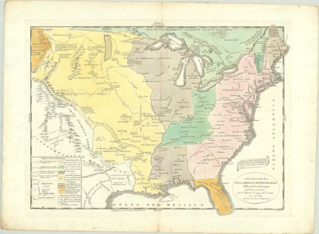
Lot 133
Subject: Eastern United States
Tasso, G.
Stati-Uniti dell' America Settentrionale dalle Piu Recenti Mappe e dall' Atl. di J.A. Buchon..., 1832
Size: 18.6 x 13.8 inches (47.2 x 35.1 cm)
Estimate: $275 - $350
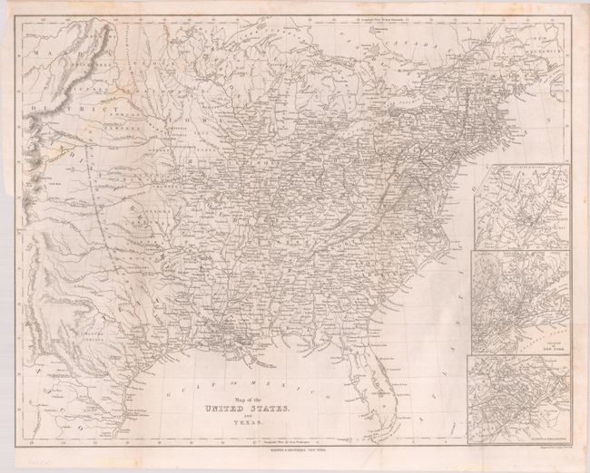
Lot 134
Subject: Eastern United States, Texas
Harper Bros.
Map of the United States, and Texas, 1844
Size: 23.8 x 17.7 inches (60.5 x 45 cm)
Estimate: $220 - $250
Lot 136
Subject: Eastern United States, Railroads
Rand McNally & Co.
[Title on Verso] 1885 - Railroad Map and Business Guide in Book Form - 1886, 1885
Size: 35.3 x 20.8 inches (89.7 x 52.8 cm)
Estimate: $275 - $350
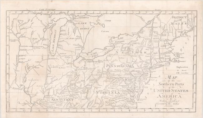
Lot 138
Subject: Central & Northeastern United States
Bradley, Abraham Jr.
Map of the Northern Parts of the United States of America , 1804
Size: 15.6 x 8.6 inches (39.6 x 21.8 cm)
Estimate: $275 - $350
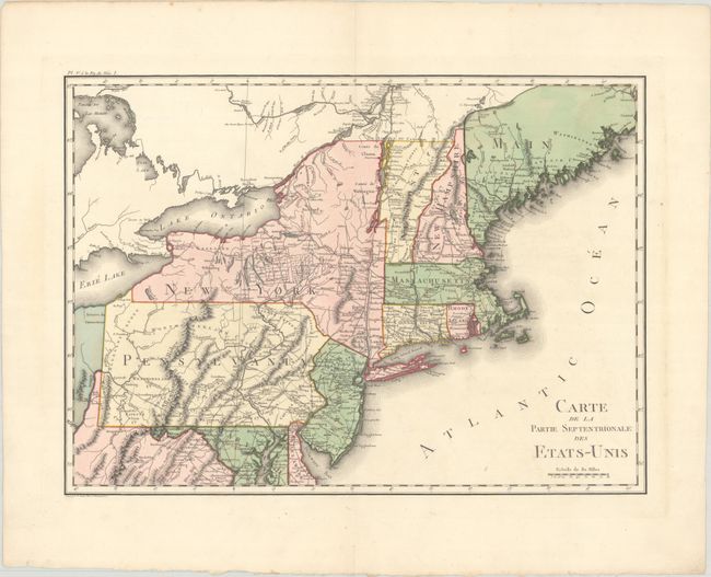
Lot 142
Subject: New England & Mid-Atlantic United States
Crevecoeur, Michel Guillaume De
Carte de la Partie Septentrionale des Etats-Unis, 1801
Size: 20 x 14.4 inches (50.8 x 36.6 cm)
Estimate: $240 - $300
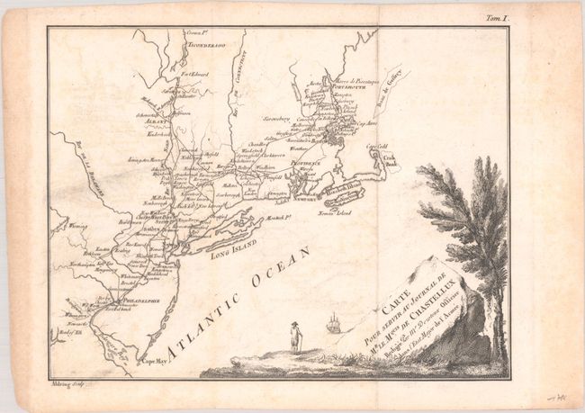
Lot 144
Subject: New England United States
Chastellux, Francois Jean, Marquis de
Carte pour Servir au Journal de Mr. le Mquis. de Chastellux, 1786
Size: 9.6 x 7.4 inches (24.4 x 18.8 cm)
Estimate: $120 - $150
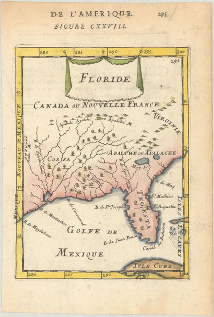
Lot 159
Subject: Colonial Southern United States
Mallet, Alain Manesson
Floride, 1683
Size: 4.6 x 6 inches (11.7 x 15.2 cm)
Estimate: $240 - $300
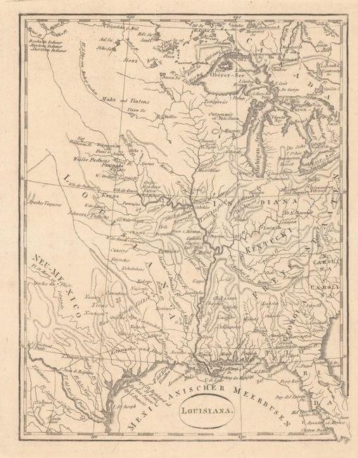
Lot 170
Subject: Central United States
Ehrmann, Theodor Friedrich
Louisiana, 1804
Size: 6.6 x 8.6 inches (16.8 x 21.8 cm)
Estimate: $275 - $350
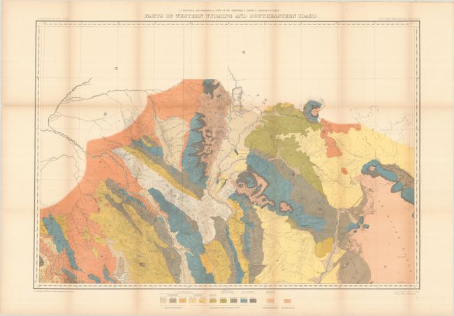
Lot 182
Subject: Wyoming & Idaho
Hayden, Ferdinand Vandeveer
[Lot of 2 - Geological and Topographical] Parts of Western Wyoming and Southeastern Idaho, 1883
Size: 32.8 x 22.8 inches (83.3 x 57.9 cm)
Estimate: $150 - $180
Locates Jackson Hole and the Tetons
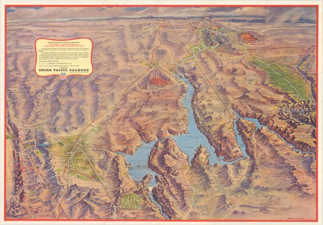
Lot 190
Subject: Southwestern United States
Eddy, Gerald
Panoramic Perspective of the Area Adjacent to Las Vegas - Hoover Dam and Lake Mead National Recreation Area, 1953
Size: 30.3 x 21 inches (77 x 53.3 cm)
Estimate: $140 - $170
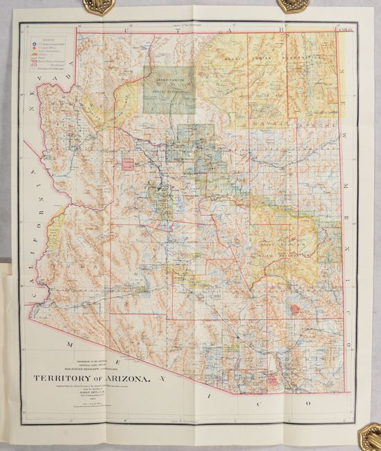
Lot 197
Subject: Arizona
General Land Office
[Map in Report] Territory of Arizona [in] Report of the Governor of Arizona to the Secretary of the Interior, 1901
Size: 16.9 x 20.3 inches (42.9 x 51.6 cm)
Estimate: $150 - $180
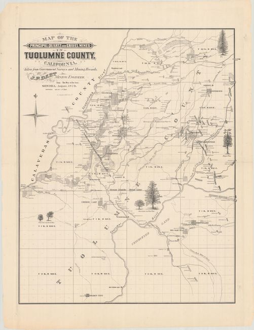
Lot 206
Subject: Tuolumne County, California
Bancroft, A.L. & Company
Map of the Principal Quartz and Gravel Mines in Tuolumne County, California. Taken from Government Surveys and Mining Records, 1879
Size: 24.3 x 30.5 inches (61.7 x 77.5 cm)
Estimate: $160 - $190
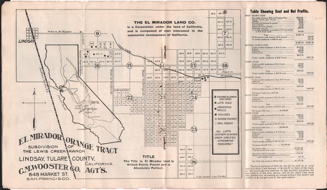
Lot 209
Subject: Central California
El Mirador Orange Tract Subdivision of the Lewis Creek Ranch Lindsay, Tulare County, California, 1905
Size: 11 x 8.3 inches (27.9 x 21.1 cm)
Estimate: $140 - $170
Early California Immigration Promotional Piece
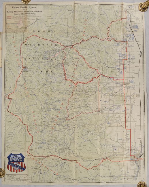
Lot 215
Subject: Colorado
Railroad Companies, (Various)
Union Pacific System Map of Rocky Mountain National (Estes) Park Denver Mountain Parks, 1924
Size: 24 x 30.6 inches (61 x 77.7 cm)
Estimate: $140 - $170
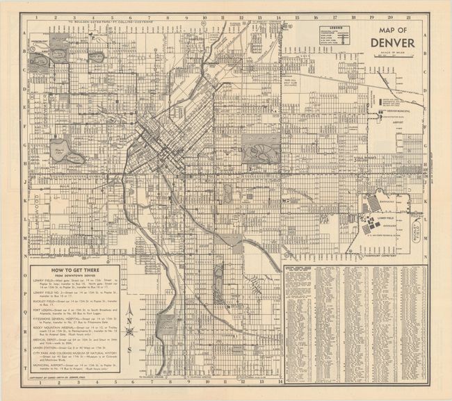
Lot 218
Subject: Denver, Colorado
Map of Denver, 1944
Size: 16.5 x 15.1 inches (41.9 x 38.4 cm)
Estimate: $140 - $170
Map Documents World War II-Era Segregation in Denver
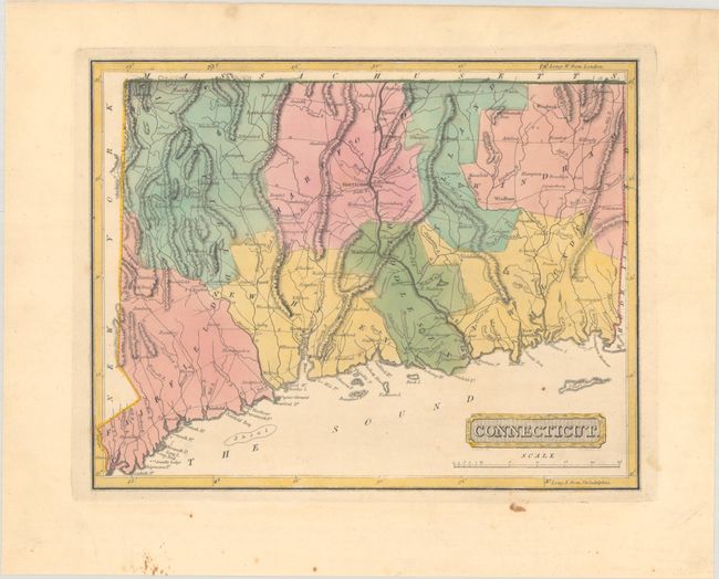
Lot 219
Subject: Connecticut
Lucas, Fielding
Connecticut, 1816
Size: 10.8 x 8.5 inches (27.4 x 21.6 cm)
Estimate: $200 - $230
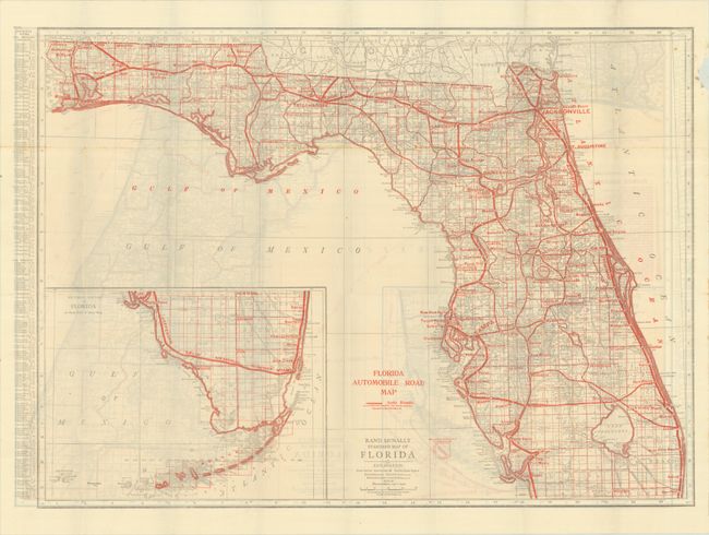
Lot 227
Subject: Florida
Rand McNally & Co.
Florida Automobile Road Map [on verso] Rand McNally Standard Map of Florida, 1921
Size: 26 x 19 inches (66 x 48.3 cm)
Estimate: $140 - $170
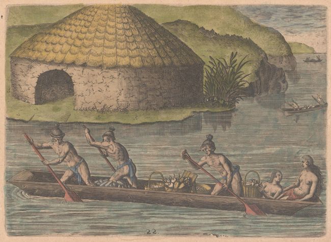
Lot 231
Subject: Florida, Natives
Bry, Theodore de
[Collecting Crops for the Communal Storehouse] Floridenses Convehendis in Publicum Horreum Fructibus Diligentes, 1609
Size: 8.3 x 6 inches (21.1 x 15.2 cm)
Estimate: $200 - $230
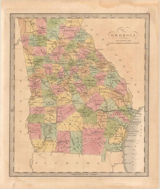
Lot 232
Subject: Georgia
Greenleaf, Jeremiah
Georgia, 1840
Size: 10.8 x 12.5 inches (27.4 x 31.8 cm)
Estimate: $200 - $230
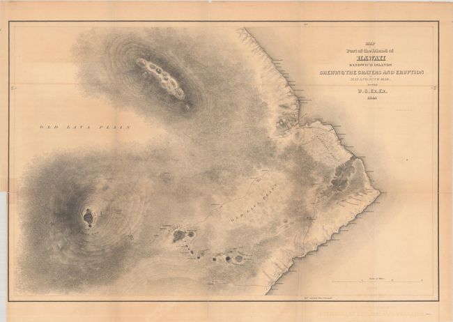
Lot 235
Subject: Hawaii
Wilkes, Charles
Map of Part of the Island of Hawaii Sandwich Islands Shewing the Craters and Eruption of May and June 1840, 1841
Size: 23.7 x 15.5 inches (60.2 x 39.4 cm)
Estimate: $200 - $230
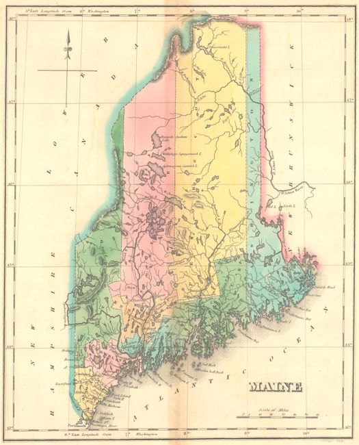
Lot 245
Subject: Maine
Carey & Lea
Geographical, Statistical, and Historical Map of Maine, 1822
Size: 9.8 x 11.9 inches (24.9 x 30.2 cm)
Estimate: $120 - $150
Lot 247
Subject: Massachusetts
Lucas, Fielding
Massachusetts, 1816
Size: 10.9 x 8.6 inches (27.7 x 21.8 cm)
Estimate: $200 - $230
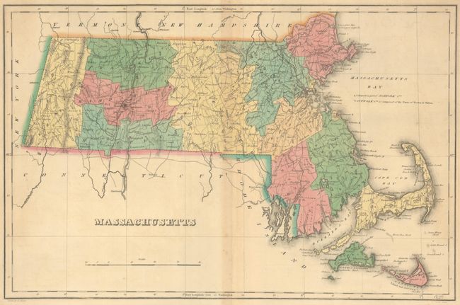
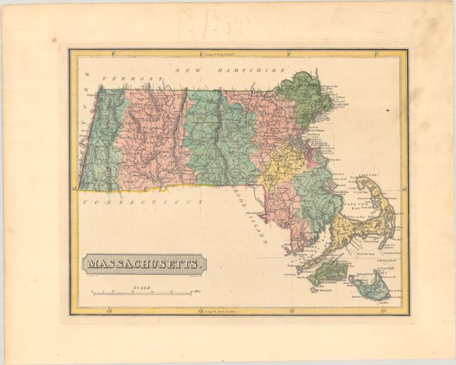
Lot 248
Subject: Massachusetts
Carey & Lea
Geographical, Historical, and Statistical Map of Massachusetts, 1822
Size: 18.1 x 11.9 inches (46 x 30.2 cm)
Estimate: $160 - $190
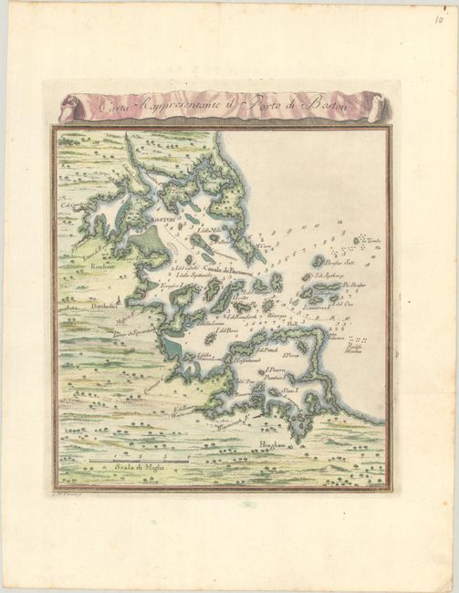
Lot 250
Subject: Boston Harbor, Massachusetts
Gazzettiere Americano
Carta Rappresentante il Porto di Boston, 1763
Size: 7.1 x 8.3 inches (18 x 21.1 cm)
Estimate: $230 - $275
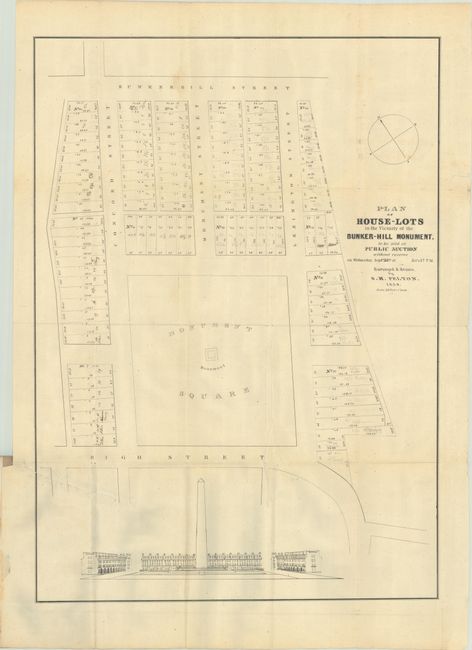
Lot 252
Subject: Boston, Massachusetts
[Map in Report] Plan of House-Lots in the Vicinity of Bunker-Hill Monument to be Sold at Public Auction... [in] Conditions of Sale of House Lots, in the Vicinity of the Bunker-Hill Monument..., 1839
Size: 20 x 27.9 inches (50.8 x 70.9 cm)
Estimate: $240 - $300
Rare Map of the Subdivision of the “Holy Ground” of the Bunker Hill Battlefield
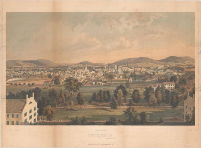
Lot 255
Subject: Pittsfield, Massachusetts
Lemercier
Pittsfield (Massachussetts.), 1854
Size: 20.9 x 12.9 inches (53.1 x 32.8 cm)
Estimate: $200 - $230
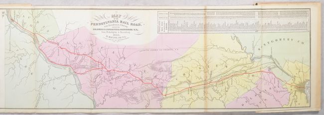
Lot 276
Subject: Pennsylvania
Duval, P.S. & Son
[Map in Book] Map of the Pennsylvania Rail Road, from Harrisburg to Pittsburg; and of the Columbia & Lancaster & Harrisburg R.Rs. from Philadelphia to Harrisburg [in] Guide for the Pennsylvania Railroad..., 1855
Size: 70.3 x 8.4 inches (178.6 x 21.3 cm)
Estimate: $200 - $230
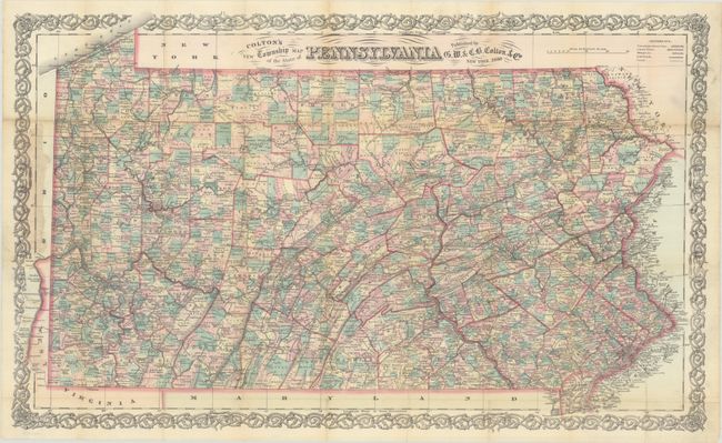
Lot 277
Subject: Pennsylvania
Colton, G.W. & C.B.
Colton's New Township Map of the State of Pennsylvania, 1880
Size: 26.6 x 16.2 inches (67.6 x 41.1 cm)
Estimate: $160 - $190
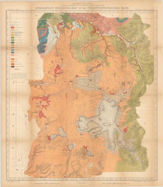
Lot 302
Subject: Yellowstone, Wyoming
Hayden, Ferdinand Vandeveer
Preliminary Geological Map of the Yellowstone National Park , 1883
Size: 28.6 x 32 inches (72.6 x 81.3 cm)
Estimate: $275 - $350
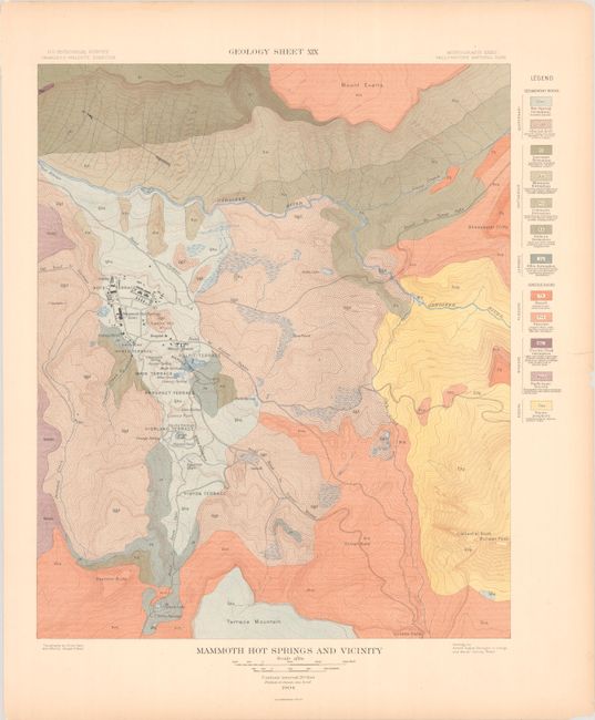
Lot 303
Subject: Yellowstone, Wyoming
U.S. Geological Survey (USGS)
[Lot of 3] Geology Sheet XIX - Mammoth Hot Springs and Vicinity [and] Topography Sheet XVIII - Mammoth Hot Springs and Vicinity [and] Topography Sheet XX - Detail Map of Mammoth Hot Springs Travertine Terraces, 1904
Size: See Description
Estimate: $140 - $170
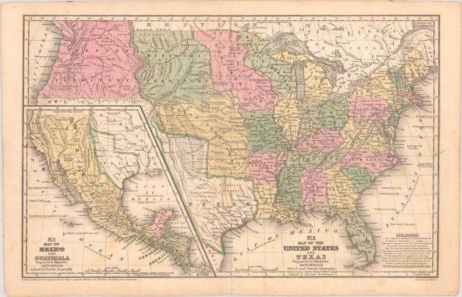
Lot 305
Subject: United States & Mexico, Texas
Mitchell, Samuel Augustus
No. 4 Map of the United States and Texas Engraved to Illustrate Mitchell's, School and Family Geography, 1839
Size: 16.6 x 10.5 inches (42.2 x 26.7 cm)
Estimate: $275 - $350
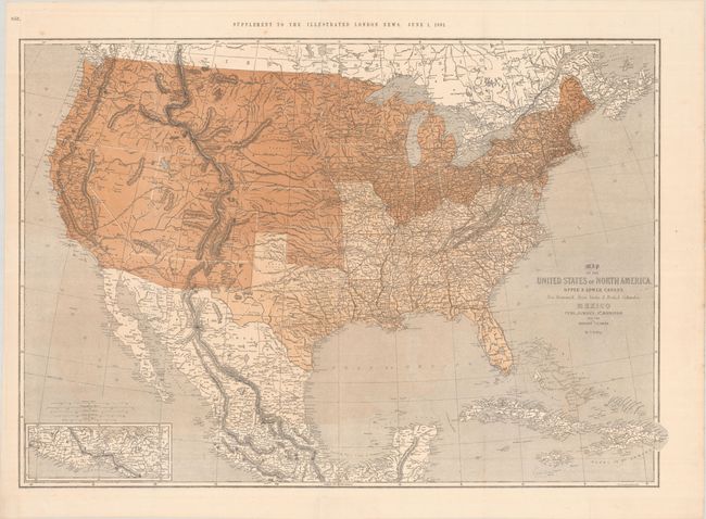
Lot 306
Subject: United States & Mexico
Ettling, Theodor
Map of the United States of North America, Upper & Lower Canada New Brunswick, Nova Scotia & British Columbia. Mexico Cuba, Jamaica, St. Domingo and the Bahama Islands, 1861
Size: 37.3 x 25.9 inches (94.7 x 65.8 cm)
Estimate: $275 - $350
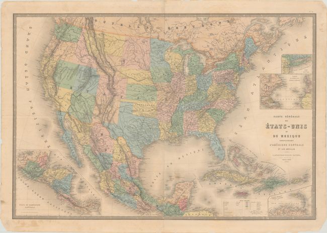
Lot 307
Subject: United States & Mexico
Andriveau-Goujon, E.
Carte Generale des Etats-Unis et du Mexique Comprenant l'Amerique Centrale et les Antilles, 1868
Size: 35.6 x 24.4 inches (90.4 x 62 cm)
Estimate: $275 - $350
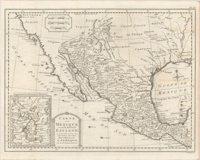
Lot 309
Subject: Western United States & Mexico
Kitchin, Thomas
Carte du Mexique ou de la Nouvelle Espagne, ou l'on Peut Suivre les Mouvemens des Costes. Pour l'Histoire de l'Amerique. Par le Dr. Robertson, 1778
Size: 14.9 x 11.2 inches (37.8 x 28.4 cm)
Estimate: $220 - $250
44 lots